Parung geodata
Parung (West Java) is a populated place; located in Indonesia in Asia/Jakarta (GMT+7) time zone. With population of 193,898 people, there are 54 cities with bigger population in this country. Compared to other cities in Indonesia, 85% of cities are located further ↓South; 86.6% of cities are located further →East and 50.3% of cities have higher elevation than Parung. Note1


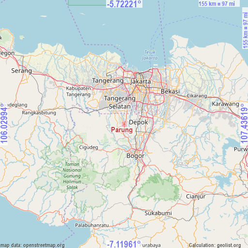
Parung GPS coordinates[2]
6° 25' 17.004" South, 106° 43' 59.016" East
| Map corner | latitude | longitude |
|---|---|---|
| Upper-left | -5.72221°, | 106.02994° |
| Center: | -6.42139°, | 106.73306° |
| Lower-right: | -7.11961°, | 107.43619° |
| Map W x H: | 155.4×155.4 km | = 96.6×96.6mi |
| max Lat: | 5.88969° ⇑15% North |
| Parung: | -6.42139° |
| min Lat: | ⇓85% South -10.934° |
| min Long | Parung | max Long |
| 95.1345° | 106.73306° | 140.9419° |
| W 13.4%⇐ | ⇒86.6% E |
Elevation
Elevation of Parung is 101 m = 331 ft, and this is 128.7 m = 422 ft below average elevation for this country.
| Max E: |
3185 m = 10449 ft | 50.3% |
| Avg. | 229.7 m = 754 ft | |
| Parung | 101 m = 331 ft | |
Min E: |
-1 m = -3 ft | 49.7% |
See also: Parung elevation on elevation.city.
Geographical zone
Parung is located in South Torrid zone (between Equator and Tropic of Capricorn). Distance of Equator is 714 km =443.7 mi to North.| Distance of | km | miles | from Parung |
|---|---|---|---|
| Equator | 714 | 443.7 | to North |
| Tropic Capricorn | 1891.9 | 1175.6 | to South |
| Antarctic Circle | 6687.2 | 4155.2 | to South |
| South Pole | 9293.1 | 5774.5 | to South |


Nearby cities:
15 places around Parung: (largest is in red/bold)
• Bogor
20.2 km =12.6 mi,  162°
162°
• Ciampea
15.2 km =9.4 mi,  193°
193°
• Cibinong
15 km =9.3 mi,  116°
116°
• Cileungsir
25.2 km =15.7 mi,  83°
83°
• Ciputat
20.9 km =13 mi,  348°
348°
• Citeureup
17.9 km =11.1 mi,  113°
113°
• Curug
26.1 km =16.2 mi,  311°
311°
• Depok
9.7 km =6 mi, 75°
• Garisul
27.8 km =17.3 mi,  250°
250°
• Jakarta
26.1 km =16.2 mi,  28°
28°
• Kadaka
28 km =17.4 mi, 247°
• Pamulang
8.8 km =5.5 mi,  3°
3°
• Sawangan
5 km =3.1 mi,  65°
65°
• Serpong
13.9 km =8.6 mi,  326°
326°
• South Tangerang
14.9 km =9.3 mi, 353°
Sources, notices
• [Note1] Compared only with cities in Indonesia existing in our database
• [Src1] Map data: © OpenStreetMap contributors (CC-BY-SA)
• [Src2] Other city data from geonames.org with taken over terms of usage.
• [Src3] Geographical zone / Annual Mean Temperature by Robert A. Rohde @ Wikipedia
