Cileungsir geodata
Cileungsir (West Java) is a populated place; located in Indonesia in Asia/Jakarta (GMT+7) time zone. With population of 202,190 people, there are 50 cities with bigger population in this country. Compared to other cities in Indonesia, 85.4% of cities are located further ↓South; 85.7% of cities are located further →East and 56.1% of cities have higher elevation than Cileungsir. Note1


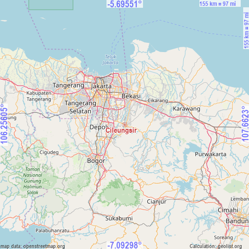
Cileungsir GPS coordinates[2]
6° 23' 40.992" South, 106° 57' 33.012" East
| Map corner | latitude | longitude |
|---|---|---|
| Upper-left | -5.69551°, | 106.25605° |
| Center: | -6.39472°, | 106.95917° |
| Lower-right: | -7.09298°, | 107.6623° |
| Map W x H: | 155.4×155.4 km | = 96.6×96.6mi |
| max Lat: | 5.88969° ⇑14.6% North |
| Cileungsir: | -6.39472° |
| min Lat: | ⇓85.4% South -10.934° |
| min Long | Cileungsir | max Long |
| 95.1345° | 106.95917° | 140.9419° |
| W 14.3%⇐ | ⇒85.7% E |
Elevation
Elevation of Cileungsir is 78 m = 256 ft, and this is 151.7 m = 498 ft below average elevation for this country.
| Max E: |
3185 m = 10449 ft | 56.1% |
| Avg. | 229.7 m = 754 ft | |
| Cileungsir | 78 m = 256 ft | |
Min E: |
-1 m = -3 ft | 43.9% |
See also: Cileungsir elevation on elevation.city.
Geographical zone
Cileungsir is located in South Torrid zone (between Equator and Tropic of Capricorn). Distance of Equator is 711 km =441.8 mi to North.| Distance of | km | miles | from Cileungsir |
|---|---|---|---|
| Equator | 711 | 441.8 | to North |
| Tropic Capricorn | 1894.9 | 1177.4 | to South |
| Antarctic Circle | 6690.1 | 4157 | to South |
| South Pole | 9296 | 5776.3 | to South |


Nearby cities:
15 places around Cileungsir: (largest is in red/bold)
• Bekasi
18.1 km =11.2 mi,  10°
10°
• Bogor
29.1 km =18.1 mi,  220°
220°
• Caringin
37.8 km =23.5 mi,  203°
203°
• Ciampea
33.6 km =20.9 mi,  238°
238°
• Cibinong
15.1 km =9.4 mi,  230°
230°
• Cikarang
26 km =16.2 mi,  55°
55°
• Ciputat
34 km =21.1 mi,  300°
300°
• Citeureup
13.2 km =8.2 mi, 220°
• Depok
15.5 km =9.6 mi,  267°
267°
• Jakarta
23.7 km =14.7 mi,  327°
327°
• Pamulang
25.1 km =15.6 mi,  283°
283°
• Parung
25.2 km =15.7 mi,  263°
263°
• Sawangan
20.4 km =12.7 mi, 267°
• Serpong
33.7 km =20.9 mi, 284°
• South Tangerang
29.2 km =18.1 mi,  293°
293°
Sources, notices
• [Note1] Compared only with cities in Indonesia existing in our database
• [Src1] Map data: © OpenStreetMap contributors (CC-BY-SA)
• [Src2] Other city data from geonames.org with taken over terms of usage.
• [Src3] Geographical zone / Annual Mean Temperature by Robert A. Rohde @ Wikipedia
