Pamulang geodata
Pamulang (West Java) is a populated place; located in Indonesia in Asia/Jakarta (GMT+7) time zone. With population of 174,557 people, there are 63 cities with bigger population in this country. Compared to other cities in Indonesia, 86.3% of cities are located further ↓South; 86.5% of cities are located further →East and 58.6% of cities have higher elevation than Pamulang. Note1


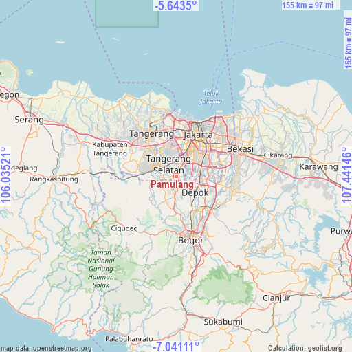
Pamulang GPS coordinates[2]
6° 20' 34.008" South, 106° 44' 17.988" East
| Map corner | latitude | longitude |
|---|---|---|
| Upper-left | -5.6435°, | 106.03521° |
| Center: | -6.34278°, | 106.73833° |
| Lower-right: | -7.04111°, | 107.44146° |
| Map W x H: | 155.4×155.4 km | = 96.6×96.6mi |
| max Lat: | 5.88969° ⇑13.7% North |
| Pamulang: | -6.34278° |
| min Lat: | ⇓86.3% South -10.934° |
| min Long | Pamulang | max Long |
| 95.1345° | 106.73833° | 140.9419° |
| W 13.5%⇐ | ⇒86.5% E |
Elevation
Elevation of Pamulang is 65 m = 213 ft, and this is 164.7 m = 540 ft below average elevation for this country.
| Max E: |
3185 m = 10449 ft | 58.6% |
| Avg. | 229.7 m = 754 ft | |
| Pamulang | 65 m = 213 ft | |
Min E: |
-1 m = -3 ft | 41.4% |
See also: Pamulang elevation on elevation.city.
Geographical zone
Pamulang is located in South Torrid zone (between Equator and Tropic of Capricorn). Distance of Equator is 705.3 km =438.3 mi to North.| Distance of | km | miles | from Pamulang |
|---|---|---|---|
| Equator | 705.3 | 438.3 | to North |
| Tropic Capricorn | 1900.7 | 1181 | to South |
| Antarctic Circle | 6695.9 | 4160.6 | to South |
| South Pole | 9301.8 | 5779.9 | to South |


Nearby cities:
15 places around Pamulang: (largest is in red/bold)
• Ciampea
23.9 km =14.9 mi,  189°
189°
• Cibinong
20.1 km =12.5 mi,  140°
140°
• Cikupa
28 km =17.4 mi,  294°
294°
• Cileungsir
25.1 km =15.6 mi,  103°
103°
• Ciputat
12.6 km =7.8 mi,  338°
338°
• Citeureup
22.4 km =13.9 mi, 135°
• Curug
21.9 km =13.6 mi, 293°
• Depok
10.9 km =6.8 mi,  125°
125°
• Jakarta
18.5 km =11.5 mi,  39°
39°
• Parung
8.8 km =5.5 mi,  183°
183°
• Sawangan
7.8 km =4.8 mi,  149°
149°
• Serpong
8.7 km =5.4 mi, 289°
• South Tangerang
6.4 km =4 mi, 339°
• Tangerang
21.9 km =13.6 mi,  326°
326°
• Tigaraksa
27.9 km =17.3 mi,  297°
297°
Sources, notices
• [Note1] Compared only with cities in Indonesia existing in our database
• [Src1] Map data: © OpenStreetMap contributors (CC-BY-SA)
• [Src2] Other city data from geonames.org with taken over terms of usage.
• [Src3] Geographical zone / Annual Mean Temperature by Robert A. Rohde @ Wikipedia
