Batang geodata
Batang (Central Java) is a populated place; located in Indonesia in Asia/Jakarta (GMT+7) time zone. With population of 115,537 people, there are 113 cities with bigger population in this country. Compared to other cities in Indonesia, 84.5% of cities are located further ↓South; 65.2% of cities are located further →East and 85.2% of cities have higher elevation than Batang. Note1


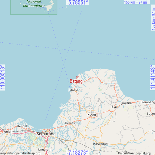
Batang GPS coordinates[2]
6° 29' 4.56" South, 110° 42' 29.88" East
| Map corner | latitude | longitude |
|---|---|---|
| Upper-left | -5.78551°, | 110.00518° |
| Center: | -6.4846°, | 110.7083° |
| Lower-right: | -7.18273°, | 111.41143° |
| Map W x H: | 155.4×155.4 km | = 96.6×96.6mi |
| max Lat: | 5.88969° ⇑15.5% North |
| Batang: | -6.4846° |
| min Lat: | ⇓84.5% South -10.934° |
| min Long | Batang | max Long |
| 95.1345° | 110.7083° | 140.9419° |
| W 34.8%⇐ | ⇒65.2% E |
Elevation
Elevation of Batang is 14 m = 46 ft, and this is 215.7 m = 708 ft below average elevation for this country.
| Max E: |
3185 m = 10449 ft | 85.2% |
| Avg. | 229.7 m = 754 ft | |
| Batang | 14 m = 46 ft | |
Min E: |
-1 m = -3 ft | 14.8% |
See also: Batang elevation on elevation.city.
Geographical zone
Batang is located in South Torrid zone (between Equator and Tropic of Capricorn). Distance of Equator is 721 km =448 mi to North.| Distance of | km | miles | from Batang |
|---|---|---|---|
| Equator | 721 | 448 | to North |
| Tropic Capricorn | 1884.9 | 1171.2 | to South |
| Antarctic Circle | 6680.2 | 4150.9 | to South |
| South Pole | 9286 | 5770.1 | to South |


Nearby cities:
15 places around Batang: (largest is in red/bold)
• Baleber
33.5 km =20.8 mi,  100°
100°
• Bancak Wetan
31.7 km =19.7 mi, 104°
• Bangkol
33.5 km =20.8 mi, 99°
• Gebog
31.6 km =19.6 mi,  151°
151°
• Gondosari
34.8 km =21.6 mi, 97°
• Gunungwungkal
32.3 km =20.1 mi,  106°
106°
• Jembul Kulon
32.8 km =20.4 mi, 102°
• Jepara
12.7 km =7.9 mi,  198°
198°
• Krajan Gajihan
34.1 km =21.2 mi, 108°
• Krajan Grogolan
34.7 km =21.6 mi,  90°
90°
• Krajan Satu Kembang
34.9 km =21.7 mi,  84°
84°
• Krajan Tegalombo
33 km =20.5 mi, 80°
• Mlonggo
5.5 km =3.4 mi,  189°
189°
• Pecangaan
23.7 km =14.7 mi,  179°
179°
• Tlogo
34.8 km =21.6 mi, 94°
Sources, notices
• [Note1] Compared only with cities in Indonesia existing in our database
• [Src1] Map data: © OpenStreetMap contributors (CC-BY-SA)
• [Src2] Other city data from geonames.org with taken over terms of usage.
• [Src3] Geographical zone / Annual Mean Temperature by Robert A. Rohde @ Wikipedia
