Pecangaan geodata
Pecangaan (Central Java) is a populated place; located in Indonesia in Asia/Jakarta (GMT+7) time zone. With population of 61,046 people, there are 196 cities with bigger population in this country. Compared to other cities in Indonesia, 80.8% of cities are located further ↓South; 65.2% of cities are located further →East and 80.9% of cities have higher elevation than Pecangaan. Note1


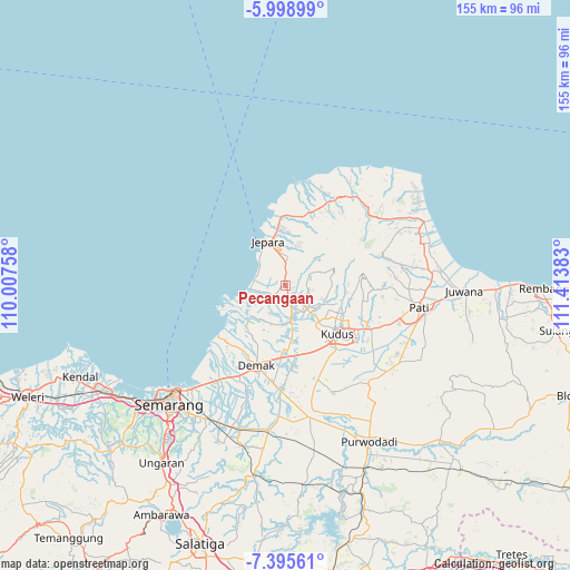
Pecangaan GPS coordinates[2]
6° 41' 52.08" South, 110° 42' 38.52" East
| Map corner | latitude | longitude |
|---|---|---|
| Upper-left | -5.99899°, | 110.00758° |
| Center: | -6.6978°, | 110.7107° |
| Lower-right: | -7.39561°, | 111.41383° |
| Map W x H: | 155.3×155.3 km | = 96.5×96.5mi |
| max Lat: | 5.88969° ⇑19.2% North |
| Pecangaan: | -6.6978° |
| min Lat: | ⇓80.8% South -10.934° |
| min Long | Pecangaan | max Long |
| 95.1345° | 110.7107° | 140.9419° |
| W 34.8%⇐ | ⇒65.2% E |
Elevation
Elevation of Pecangaan is 18 m = 59 ft, and this is 211.7 m = 695 ft below average elevation for this country.
| Max E: |
3185 m = 10449 ft | 80.9% |
| Avg. | 229.7 m = 754 ft | |
| Pecangaan | 18 m = 59 ft | |
Min E: |
-1 m = -3 ft | 19.1% |
See also: Pecangaan elevation on elevation.city.
Geographical zone
Pecangaan is located in South Torrid zone (between Equator and Tropic of Capricorn). Distance of Equator is 744.7 km =462.7 mi to North.| Distance of | km | miles | from Pecangaan |
|---|---|---|---|
| Equator | 744.7 | 462.7 | to North |
| Tropic Capricorn | 1861.2 | 1156.5 | to South |
| Antarctic Circle | 6656.4 | 4136.1 | to South |
| South Pole | 9262.3 | 5755.3 | to South |


Nearby cities:
15 places around Pecangaan: (largest is in red/bold)
• Baekrajan
17.6 km =10.9 mi,  116°
116°
• Batang
23.7 km =14.7 mi,  359°
359°
• Cabak Satu
32.3 km =20.1 mi,  75°
75°
• Demak
22.9 km =14.2 mi,  200°
200°
• Gebog
15.3 km =9.5 mi,  105°
105°
• Jekulo
26.6 km =16.5 mi, 116°
• Jepara
12.5 km =7.8 mi,  339°
339°
• Kudus
18.6 km =11.6 mi,  129°
129°
• Lahar
31.8 km =19.8 mi, 79°
• Mlonggo
18.3 km =11.4 mi, 356°
• Purwosari
32.1 km =19.9 mi,  90°
90°
• Randangan
30.8 km =19.1 mi, 92°
• Sanglur
32.5 km =20.2 mi, 83°
• Tlogowungu
33.5 km =20.8 mi, 91°
• Welahan
11.4 km =7.1 mi,  176°
176°
Sources, notices
• [Note1] Compared only with cities in Indonesia existing in our database
• [Src1] Map data: © OpenStreetMap contributors (CC-BY-SA)
• [Src2] Other city data from geonames.org with taken over terms of usage.
• [Src3] Geographical zone / Annual Mean Temperature by Robert A. Rohde @ Wikipedia
