Wates geodata
Wates (Yogyakarta) is a seat of a second-order administrative division; located in Indonesia in Asia/Jakarta (GMT+7) time zone. In our database, there are 407 cities with bigger population. Compared to other cities in Indonesia, 61% of cities are located further ↑North; 65.7% of cities are located further →East and 76.2% of cities have higher elevation than Wates. Note1


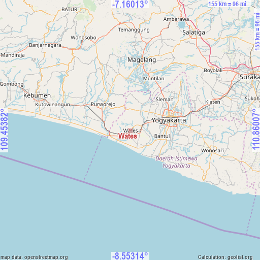
Wates GPS coordinates[2]
7° 51' 25.992" South, 110° 9' 24.984" East
| Map corner | latitude | longitude |
|---|---|---|
| Upper-left | -7.16013°, | 109.45382° |
| Center: | -7.85722°, | 110.15694° |
| Lower-right: | -8.55314°, | 110.86007° |
| Map W x H: | 154.9×154.9 km | = 96.3×96.3mi |
| max Lat: | 5.88969° ⇑61% North |
| Wates: | -7.85722° |
| min Lat: | ⇓39% South -10.934° |
| min Long | Wates | max Long |
| 95.1345° | 110.15694° | 140.9419° |
| W 34.3%⇐ | ⇒65.7% E |
Elevation
Elevation of Wates is 23 m = 75 ft, and this is 206.7 m = 678 ft below average elevation for this country.
| Max E: |
3185 m = 10449 ft | 76.2% |
| Avg. | 229.7 m = 754 ft | |
| Wates | 23 m = 75 ft | |
Min E: |
-1 m = -3 ft | 23.8% |
See also: Indonesia elevation on elevation.city.
Geographical zone
Wates is located in South Torrid zone (between Equator and Tropic of Capricorn). Distance of Equator is 873.6 km =542.8 mi to North.| Distance of | km | miles | from Wates |
|---|---|---|---|
| Equator | 873.6 | 542.8 | to North |
| Tropic Capricorn | 1732.3 | 1076.4 | to South |
| Antarctic Circle | 6527.5 | 4056 | to South |
| South Pole | 9133.4 | 5675.2 | to South |


Nearby cities:
15 places around Wates: (largest is in red/bold)
• Bambanglipuro
17.3 km =10.7 mi,  126°
126°
• Bantul
19.2 km =11.9 mi,  100°
100°
• Gamping Lor
19.9 km =12.4 mi,  69°
69°
• Godean
18 km =11.2 mi,  57°
57°
• Kasihan
19.3 km =12 mi,  79°
79°
• Melati
26.9 km =16.7 mi, 59°
• Mungkid
30.2 km =18.8 mi,  13°
13°
• Pandak
16.3 km =10.1 mi,  112°
112°
• Pugeran Maguwoharjo
30.8 km =19.1 mi, 71°
• Pundong
23.6 km =14.7 mi,  116°
116°
• Purworejo
22.9 km =14.2 mi,  315°
315°
• Sewon
22.3 km =13.9 mi, 95°
• Sleman
27 km =16.8 mi,  54°
54°
• Srandakan
13.7 km =8.5 mi, 131°
• Yogyakarta
23.7 km =14.7 mi, 74°
Sources, notices
• [Note1] Compared only with cities in Indonesia existing in our database
• [Src1] Map data: © OpenStreetMap contributors (CC-BY-SA)
• [Src2] Other city data from geonames.org with taken over terms of usage.
• [Src3] Geographical zone / Annual Mean Temperature by Robert A. Rohde @ Wikipedia
