Tobercurry geodata
Tobercurry (Connaught) is a populated place; located in Ireland in Europe/Dublin (GMT+1) time zone. With population of 1,747 people, there are 248 cities with bigger population in this country. Compared to other cities in Ireland, 88.4% of cities are located further ↓South; 82.5% of cities are located further →East and 82.4% of cities have lower elevation than Tobercurry. Note1


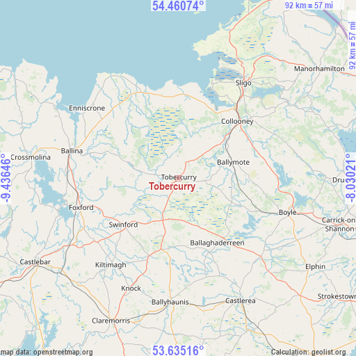
Tobercurry GPS coordinates[2]
54° 3' 0" North, 8° 43' 59.988" West
| Map corner | latitude | longitude |
|---|---|---|
| Upper-left | 54.46074°, | -9.43646° |
| Center: | 54.05°, | -8.73333° |
| Lower-right: | 53.63516°, | -8.03021° |
| Map W x H: | 91.8×91.8 km | = 57×57mi |
| max Lat: | 55.25° ⇑11.6% North |
| Tobercurry: | 54.05° |
| min Lat: | ⇓88.4% South 51.52487° |
| min Long | Tobercurry | max Long |
| -10.26889° | -8.73333° | -6.04944° |
| W 17.5%⇐ | ⇒82.5% E |
Elevation
Elevation of Tobercurry is 92 m = 302 ft, and this is 37.5 m = 123 ft above average elevation for this country.
| Max E: |
262 m = 860 ft | 17.6% |
| Tobercurry | 92 m 302 ft | |
| Avg. | 54.5 m = 179 ft | |
Min E: |
0 m = 0 ft | 82.4% |
See also: Ireland elevation on elevation.city.
Geographical zone
Tobercurry is located in North temperate zone (between Tropic of Cancer and the Arctic Circle). Distance of this North polar circle is 1391.4 km =864.6 mi to North.| Distance of | km | miles | from Tobercurry |
|---|---|---|---|
| North Pole | 3997.3 | 2483.8 | to North |
| Arctic Circle | 1391.4 | 864.6 | to North |
| Tropic Cancer | 3403.9 | 2115.1 | to South |
| Equator | 6009.8 | 3734.3 | to South |


Nearby cities:
15 places around Tobercurry: (largest is in red/bold)
• Ballaghaderreen
19.3 km =12 mi,  149°
149°
• Ballina
29.2 km =18.1 mi,  284°
284°
• Ballisodare
23.1 km =14.4 mi,  39°
39°
• Ballymote
14.6 km =9.1 mi,  75°
75°
• Boyle
29.8 km =18.5 mi,  108°
108°
• Charlestown
10.3 km =6.4 mi,  202°
202°
• Collooney
21.2 km =13.2 mi,  45°
45°
• Coolaney
16.7 km =10.4 mi,  31°
31°
• Foxford
26.1 km =16.2 mi,  252°
252°
• Inishcrone
29.8 km =18.5 mi,  308°
308°
• Kiltamagh
28.3 km =17.6 mi,  218°
218°
• Rosses Point
30.8 km =19.1 mi,  20°
20°
• Sligo
29.9 km =18.6 mi, 35°
• Strandhill
26.3 km =16.3 mi, 20°
• Swinford
18 km =11.2 mi,  231°
231°
Sources, notices
• [Note1] Compared only with cities in Ireland existing in our database
• [Src1] Map data: © OpenStreetMap contributors (CC-BY-SA)
• [Src2] Other city data from geonames.org with taken over terms of usage.
• [Src3] Geographical zone / Annual Mean Temperature by Robert A. Rohde @ Wikipedia
