Rivermeade geodata
Rivermeade (Leinster) is a populated place; located in Ireland in Europe/Dublin (GMT+1) time zone. With population of 543 people, there are 504 cities with bigger population in this country. Compared to other cities in Ireland, 69.8% of cities are located further ↓South; 84.1% of cities are located further ←West and 62.6% of cities have lower elevation than Rivermeade. Note1


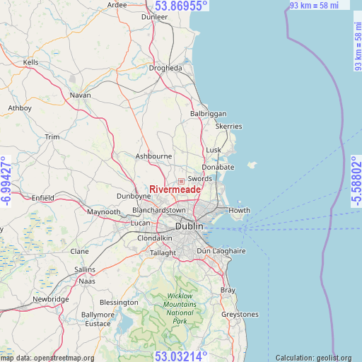
Rivermeade GPS coordinates[2]
53° 27' 10.476" North, 6° 17' 28.14" West
| Map corner | latitude | longitude |
|---|---|---|
| Upper-left | 53.86955°, | -6.99427° |
| Center: | 53.45291°, | -6.29115° |
| Lower-right: | 53.03214°, | -5.58802° |
| Map W x H: | 93.1×93.1 km | = 57.8×57.8mi |
| max Lat: | 55.25° ⇑30.2% North |
| Rivermeade: | 53.45291° |
| min Lat: | ⇓69.8% South 51.52487° |
| min Long | Rivermeade | max Long |
| -10.26889° | -6.29115° | -6.04944° |
| W 84.1%⇐ | ⇒15.9% E |
Elevation
Elevation of Rivermeade is 62 m = 203 ft, and this is 7.5 m = 25 ft above average elevation for this country.
| Max E: |
262 m = 860 ft | 37.4% |
| Rivermeade | 62 m 203 ft | |
| Avg. | 54.5 m = 179 ft | |
Min E: |
0 m = 0 ft | 62.6% |
See also: Ireland elevation on elevation.city.
Geographical zone
Rivermeade is located in North temperate zone (between Tropic of Cancer and the Arctic Circle). Distance of this North polar circle is 1457.8 km =905.8 mi to North.| Distance of | km | miles | from Rivermeade |
|---|---|---|---|
| North Pole | 4063.7 | 2525.1 | to North |
| Arctic Circle | 1457.8 | 905.8 | to North |
| Tropic Cancer | 3337.5 | 2073.8 | to South |
| Equator | 5943.4 | 3693.1 | to South |


Nearby cities:
15 places around Rivermeade: (largest is in red/bold)
• Artane
8.9 km =5.5 mi,  144°
144°
• Ashbourne
9.6 km =6 mi,  312°
312°
• Ballymun
6.3 km =3.9 mi,  165°
165°
• Beaumont
8.4 km =5.2 mi,  149°
149°
• Blanchardstown
9.1 km =5.7 mi,  217°
217°
• Bonnybrook
8.2 km =5.1 mi, 137°
• Cabra
9.6 km =6 mi,  181°
181°
• Coolock
9.4 km =5.8 mi, 139°
• Darndale
9 km =5.6 mi,  131°
131°
• Drumcondra
9.5 km =5.9 mi,  164°
164°
• Finglas
7.1 km =4.4 mi, 183°
• Glasnevin
8.3 km =5.2 mi, 175°
• Kinsealy-Drinan
5.9 km =3.7 mi,  99°
99°
• Malahide
9.1 km =5.7 mi,  91°
91°
• Swords
4.9 km =3 mi,  81°
81°
Sources, notices
• [Note1] Compared only with cities in Ireland existing in our database
• [Src1] Map data: © OpenStreetMap contributors (CC-BY-SA)
• [Src2] Other city data from geonames.org with taken over terms of usage.
• [Src3] Geographical zone / Annual Mean Temperature by Robert A. Rohde @ Wikipedia
