Ballymun geodata
Ballymun (Leinster) is a populated place; located in Ireland in Europe/Dublin (GMT+1) time zone. With population of 6,262 people, there are 111 cities with bigger population in this country. Compared to other cities in Ireland, 66.4% of cities are located further ↓South; 85.6% of cities are located further ←West and 62.6% of cities have lower elevation than Ballymun. Note1


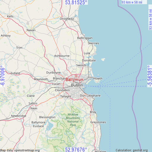
Ballymun GPS coordinates[2]
53° 23' 53.052" North, 6° 16' 0.948" West
| Map corner | latitude | longitude |
|---|---|---|
| Upper-left | 53.81525°, | -6.97006° |
| Center: | 53.39807°, | -6.26693° |
| Lower-right: | 52.97676°, | -5.56381° |
| Map W x H: | 93.2×93.2 km | = 57.9×57.9mi |
| max Lat: | 55.25° ⇑33.6% North |
| Ballymun: | 53.39807° |
| min Lat: | ⇓66.4% South 51.52487° |
| min Long | Ballymun | max Long |
| -10.26889° | -6.26693° | -6.04944° |
| W 85.6%⇐ | ⇒14.4% E |
Elevation
Elevation of Ballymun is 62 m = 203 ft, and this is 7.5 m = 25 ft above average elevation for this country.
| Max E: |
262 m = 860 ft | 37.4% |
| Ballymun | 62 m 203 ft | |
| Avg. | 54.5 m = 179 ft | |
Min E: |
0 m = 0 ft | 62.6% |
See also: Ireland elevation on elevation.city.
Geographical zone
Ballymun is located in North temperate zone (between Tropic of Cancer and the Arctic Circle). Distance of this North polar circle is 1463.9 km =909.6 mi to North.| Distance of | km | miles | from Ballymun |
|---|---|---|---|
| North Pole | 4069.8 | 2528.9 | to North |
| Arctic Circle | 1463.9 | 909.6 | to North |
| Tropic Cancer | 3331.4 | 2070 | to South |
| Equator | 5937.3 | 3689.3 | to South |


Nearby cities:
15 places around Ballymun: (largest is in red/bold)
• Artane
3.7 km =2.3 mi,  109°
109°
• Beaumont
2.9 km =1.8 mi, 114°
• Bonnybrook
3.9 km =2.4 mi,  89°
89°
• Cabra
3.9 km =2.4 mi,  207°
207°
• Coolock
4.6 km =2.9 mi,  103°
103°
• Darndale
5.2 km =3.2 mi, 88°
• Donnycarney
4.7 km =2.9 mi,  125°
125°
• Drumcondra
3.2 km =2 mi,  163°
163°
• Fairview
4 km =2.5 mi,  153°
153°
• Finglas
2.2 km =1.4 mi,  243°
243°
• Glasnevin
2.3 km =1.4 mi,  202°
202°
• Killester
5 km =3.1 mi,  123°
123°
• Marino
3.7 km =2.3 mi, 146°
• Raheny
5.9 km =3.7 mi, 102°
• Rivermeade
6.3 km =3.9 mi,  345°
345°
Sources, notices
• [Note1] Compared only with cities in Ireland existing in our database
• [Src1] Map data: © OpenStreetMap contributors (CC-BY-SA)
• [Src2] Other city data from geonames.org with taken over terms of usage.
• [Src3] Geographical zone / Annual Mean Temperature by Robert A. Rohde @ Wikipedia
