Shankill geodata
Shankill (Leinster) is a populated place; located in Ireland in Europe/Dublin (GMT+1) time zone. With population of 10,102 people, there are 54 cities with bigger population in this country. Compared to other cities in Ireland, 52% of cities are located further ↑North; 96.4% of cities are located further ←West and 63% of cities have higher elevation than Shankill. Note1


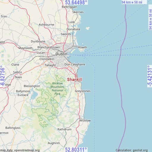
Shankill GPS coordinates[2]
53° 13' 33.996" North, 6° 7' 27.984" West
| Map corner | latitude | longitude |
|---|---|---|
| Upper-left | 53.64498°, | -6.82756° |
| Center: | 53.22611°, | -6.12444° |
| Lower-right: | 52.80311°, | -5.42131° |
| Map W x H: | 93.6×93.6 km | = 58.2×58.2mi |
| max Lat: | 55.25° ⇑52% North |
| Shankill: | 53.22611° |
| min Lat: | ⇓48% South 51.52487° |
| min Long | Shankill | max Long |
| -10.26889° | -6.12444° | -6.04944° |
| W 96.4%⇐ | ⇒3.6% E |
Elevation
Elevation of Shankill is 33 m = 108 ft, and this is 21.5 m = 71 ft below average elevation for this country.
| Max E: |
262 m = 860 ft | 63% |
| Avg. | 54.5 m = 179 ft | |
| Shankill | 33 m = 108 ft | |
Min E: |
0 m = 0 ft | 37% |
See also: Ireland elevation on elevation.city.
Geographical zone
Shankill is located in North temperate zone (between Tropic of Cancer and the Arctic Circle). Distance of this North polar circle is 1483 km =921.5 mi to North.| Distance of | km | miles | from Shankill |
|---|---|---|---|
| North Pole | 4088.9 | 2540.7 | to North |
| Arctic Circle | 1483 | 921.5 | to North |
| Tropic Cancer | 3312.3 | 2058.2 | to South |
| Equator | 5918.2 | 3677.4 | to South |


Nearby cities:
15 places around Shankill: (largest is in red/bold)
• Balally
9.2 km =5.7 mi,  306°
306°
• Ballinteer
10.1 km =6.3 mi,  301°
301°
• Blackrock
9.1 km =5.7 mi,  337°
337°
• Bray
3.1 km =1.9 mi,  146°
146°
• Cabinteely
5.4 km =3.4 mi,  333°
333°
• Dalkey
6 km =3.7 mi,  15°
15°
• Dún Laoghaire
7.6 km =4.7 mi,  354°
354°
• Enniskerry
4.8 km =3 mi,  218°
218°
• Foxrock
5.6 km =3.5 mi,  323°
323°
• Kilmacanoge
6.6 km =4.1 mi,  185°
185°
• Little Bray
2.4 km =1.5 mi,  174°
174°
• Loughlinstown
2.1 km =1.3 mi, 343°
• Monkstown
7.7 km =4.8 mi, 345°
• Sallynoggin
6 km =3.7 mi, 349°
• Sandyford
8.6 km =5.3 mi, 308°
Sources, notices
• [Note1] Compared only with cities in Ireland existing in our database
• [Src1] Map data: © OpenStreetMap contributors (CC-BY-SA)
• [Src2] Other city data from geonames.org with taken over terms of usage.
• [Src3] Geographical zone / Annual Mean Temperature by Robert A. Rohde @ Wikipedia
