Loughlinstown geodata
Loughlinstown (Leinster) is a populated place; located in Ireland in Europe/Dublin (GMT+1) time zone. With population of 3,665 people, there are 170 cities with bigger population in this country. Compared to other cities in Ireland, 51.2% of cities are located further ↑North; 96% of cities are located further ←West and 80.5% of cities have higher elevation than Loughlinstown. Note1


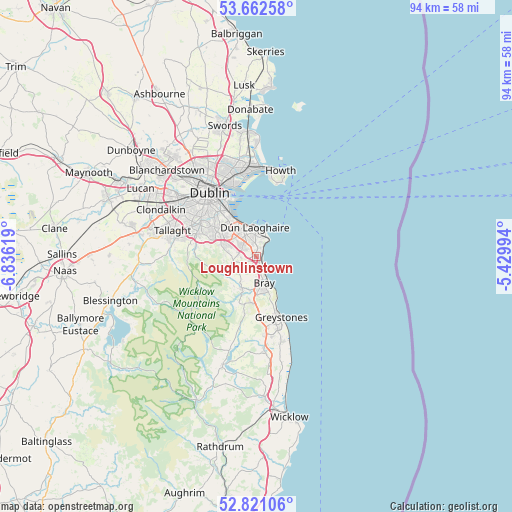
Loughlinstown GPS coordinates[2]
53° 14' 38.004" North, 6° 7' 59.016" West
| Map corner | latitude | longitude |
|---|---|---|
| Upper-left | 53.66258°, | -6.83619° |
| Center: | 53.24389°, | -6.13306° |
| Lower-right: | 52.82106°, | -5.42994° |
| Map W x H: | 93.6×93.6 km | = 58.2×58.2mi |
| max Lat: | 55.25° ⇑51.2% North |
| Loughlinstown: | 53.24389° |
| min Lat: | ⇓48.8% South 51.52487° |
| min Long | Loughlinstown | max Long |
| -10.26889° | -6.13306° | -6.04944° |
| W 96%⇐ | ⇒4% E |
Elevation
Elevation of Loughlinstown is 17 m = 56 ft, and this is 37.5 m = 123 ft below average elevation for this country.
| Max E: |
262 m = 860 ft | 80.5% |
| Avg. | 54.5 m = 179 ft | |
| Loughlinstown | 17 m = 56 ft | |
Min E: |
0 m = 0 ft | 19.5% |
See also: Ireland elevation on elevation.city.
Geographical zone
Loughlinstown is located in North temperate zone (between Tropic of Cancer and the Arctic Circle). Distance of this North polar circle is 1481 km =920.3 mi to North.| Distance of | km | miles | from Loughlinstown |
|---|---|---|---|
| North Pole | 4086.9 | 2539.5 | to North |
| Arctic Circle | 1481 | 920.3 | to North |
| Tropic Cancer | 3314.2 | 2059.3 | to South |
| Equator | 5920.2 | 3678.6 | to South |


Nearby cities:
15 places around Loughlinstown: (largest is in red/bold)
• Balally
7.7 km =4.8 mi,  296°
296°
• Blackrock
7.1 km =4.4 mi,  335°
335°
• Booterstown
8.1 km =5 mi,  326°
326°
• Bray
5.1 km =3.2 mi,  153°
153°
• Cabinteely
3.4 km =2.1 mi, 327°
• Dalkey
4.4 km =2.7 mi,  29°
29°
• Dún Laoghaire
5.6 km =3.5 mi,  358°
358°
• Enniskerry
6.2 km =3.9 mi,  202°
202°
• Foxrock
3.7 km =2.3 mi,  312°
312°
• Little Bray
4.5 km =2.8 mi,  169°
169°
• Monkstown
5.6 km =3.5 mi,  346°
346°
• Mount Merrion
8.3 km =5.2 mi,  318°
318°
• Sallynoggin
4 km =2.5 mi, 352°
• Sandyford
7 km =4.3 mi, 299°
• Shankill
2.1 km =1.3 mi,  163°
163°
Sources, notices
• [Note1] Compared only with cities in Ireland existing in our database
• [Src1] Map data: © OpenStreetMap contributors (CC-BY-SA)
• [Src2] Other city data from geonames.org with taken over terms of usage.
• [Src3] Geographical zone / Annual Mean Temperature by Robert A. Rohde @ Wikipedia
