Dalkey geodata
Dalkey (Leinster) is a populated place; located in Ireland in Europe/Dublin (GMT+1) time zone. With population of 6,622 people, there are 105 cities with bigger population in this country. Compared to other cities in Ireland, 52% of cities are located further ↓South; 98.1% of cities are located further ←West and 77.2% of cities have higher elevation than Dalkey. Note1


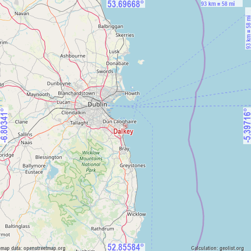
Dalkey GPS coordinates[2]
53° 16' 41.988" North, 6° 6' 1.008" West
| Map corner | latitude | longitude |
|---|---|---|
| Upper-left | 53.69668°, | -6.80341° |
| Center: | 53.27833°, | -6.10028° |
| Lower-right: | 52.85584°, | -5.39716° |
| Map W x H: | 93.5×93.5 km | = 58.1×58.1mi |
| max Lat: | 55.25° ⇑48% North |
| Dalkey: | 53.27833° |
| min Lat: | ⇓52% South 51.52487° |
| min Long | Dalkey | max Long |
| -10.26889° | -6.10028° | -6.04944° |
| W 98.1%⇐ | ⇒1.9% E |
Elevation
Elevation of Dalkey is 19 m = 62 ft, and this is 35.5 m = 116 ft below average elevation for this country.
| Max E: |
262 m = 860 ft | 77.2% |
| Avg. | 54.5 m = 179 ft | |
| Dalkey | 19 m = 62 ft | |
Min E: |
0 m = 0 ft | 22.8% |
See also: Ireland elevation on elevation.city.
Geographical zone
Dalkey is located in North temperate zone (between Tropic of Cancer and the Arctic Circle). Distance of this North polar circle is 1477.2 km =917.9 mi to North.| Distance of | km | miles | from Dalkey |
|---|---|---|---|
| North Pole | 4083.1 | 2537.1 | to North |
| Arctic Circle | 1477.2 | 917.9 | to North |
| Tropic Cancer | 3318.1 | 2061.8 | to South |
| Equator | 5924 | 3681 | to South |


Nearby cities:
15 places around Dalkey: (largest is in red/bold)
• Balally
9 km =5.6 mi,  267°
267°
• Blackrock
5.8 km =3.6 mi,  296°
296°
• Booterstown
7.2 km =4.5 mi,  293°
293°
• Bray
8.4 km =5.2 mi,  179°
179°
• Cabinteely
4.1 km =2.5 mi,  256°
256°
• Donnybrook
9 km =5.6 mi, 295°
• Dún Laoghaire
2.9 km =1.8 mi,  306°
306°
• Foxrock
5.1 km =3.2 mi, 255°
• Little Bray
8.3 km =5.2 mi,  189°
189°
• Loughlinstown
4.4 km =2.7 mi,  209°
209°
• Monkstown
3.9 km =2.4 mi, 295°
• Mount Merrion
8 km =5 mi, 287°
• Sallynoggin
2.7 km =1.7 mi, 271°
• Sandyford
8.3 km =5.2 mi, 267°
• Shankill
6 km =3.7 mi,  195°
195°
Sources, notices
• [Note1] Compared only with cities in Ireland existing in our database
• [Src1] Map data: © OpenStreetMap contributors (CC-BY-SA)
• [Src2] Other city data from geonames.org with taken over terms of usage.
• [Src3] Geographical zone / Annual Mean Temperature by Robert A. Rohde @ Wikipedia
