Blackrock geodata
Blackrock (Leinster) is a populated place; located in Ireland in Europe/Dublin (GMT+1) time zone. With population of 8,821 people, there are 71 cities with bigger population in this country. Compared to other cities in Ireland, 56% of cities are located further ↓South; 93% of cities are located further ←West and 82.9% of cities have higher elevation than Blackrock. Note1


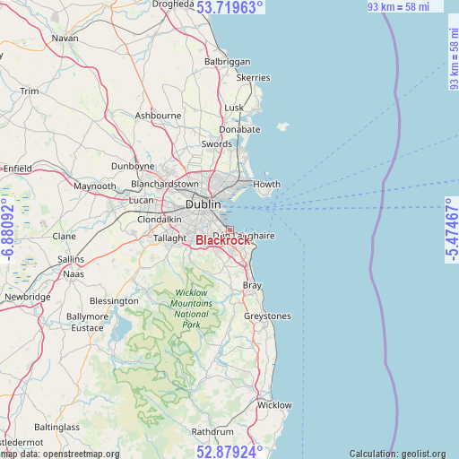
Blackrock GPS coordinates[2]
53° 18' 5.4" North, 6° 10' 40.08" West
| Map corner | latitude | longitude |
|---|---|---|
| Upper-left | 53.71963°, | -6.88092° |
| Center: | 53.3015°, | -6.1778° |
| Lower-right: | 52.87924°, | -5.47467° |
| Map W x H: | 93.4×93.4 km | = 58×58mi |
| max Lat: | 55.25° ⇑44% North |
| Blackrock: | 53.3015° |
| min Lat: | ⇓56% South 51.52487° |
| min Long | Blackrock | max Long |
| -10.26889° | -6.1778° | -6.04944° |
| W 93%⇐ | ⇒7% E |
Elevation
Elevation of Blackrock is 15 m = 49 ft, and this is 39.5 m = 130 ft below average elevation for this country.
| Max E: |
262 m = 860 ft | 82.9% |
| Avg. | 54.5 m = 179 ft | |
| Blackrock | 15 m = 49 ft | |
Min E: |
0 m = 0 ft | 17.1% |
See also: Ireland elevation on elevation.city.
Geographical zone
Blackrock is located in North temperate zone (between Tropic of Cancer and the Arctic Circle). Distance of this North polar circle is 1474.6 km =916.3 mi to North.| Distance of | km | miles | from Blackrock |
|---|---|---|---|
| North Pole | 4080.5 | 2535.5 | to North |
| Arctic Circle | 1474.6 | 916.3 | to North |
| Tropic Cancer | 3320.7 | 2063.4 | to South |
| Equator | 5926.6 | 3682.6 | to South |


Nearby cities:
15 places around Blackrock: (largest is in red/bold)
• Balally
4.9 km =3 mi,  232°
232°
• Booterstown
1.5 km =0.9 mi,  282°
282°
• Cabinteely
3.7 km =2.3 mi,  162°
162°
• Clonskeagh
3.9 km =2.4 mi,  292°
292°
• Donnybrook
3.3 km =2.1 mi, 294°
• Dundrum
5.4 km =3.4 mi,  257°
257°
• Dún Laoghaire
2.9 km =1.8 mi,  106°
106°
• Foxrock
3.9 km =2.4 mi,  176°
176°
• Milltown
4.7 km =2.9 mi, 285°
• Monkstown
1.9 km =1.2 mi,  119°
119°
• Mount Merrion
2.5 km =1.6 mi,  266°
266°
• Ringsend
5.5 km =3.4 mi,  324°
324°
• Sallynoggin
3.5 km =2.2 mi,  135°
135°
• Sandyford
4.3 km =2.7 mi, 226°
• Sandymount
4.2 km =2.6 mi, 315°
Sources, notices
• [Note1] Compared only with cities in Ireland existing in our database
• [Src1] Map data: © OpenStreetMap contributors (CC-BY-SA)
• [Src2] Other city data from geonames.org with taken over terms of usage.
• [Src3] Geographical zone / Annual Mean Temperature by Robert A. Rohde @ Wikipedia
