Enniskerry geodata
Enniskerry (Leinster) is a populated place; located in Ireland in Europe/Dublin (GMT+1) time zone. With population of 1,811 people, there are 241 cities with bigger population in this country. Compared to other cities in Ireland, 53.5% of cities are located further ↑North; 93.4% of cities are located further ←West and 69.1% of cities have lower elevation than Enniskerry. Note1


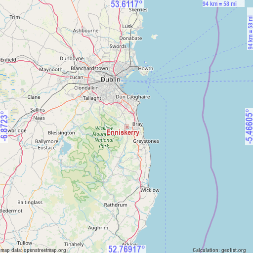
Enniskerry GPS coordinates[2]
53° 11' 33" North, 6° 10' 9.012" West
| Map corner | latitude | longitude |
|---|---|---|
| Upper-left | 53.6117°, | -6.8723° |
| Center: | 53.1925°, | -6.16917° |
| Lower-right: | 52.76917°, | -5.46605° |
| Map W x H: | 93.7×93.7 km | = 58.2×58.2mi |
| max Lat: | 55.25° ⇑53.5% North |
| Enniskerry: | 53.1925° |
| min Lat: | ⇓46.5% South 51.52487° |
| min Long | Enniskerry | max Long |
| -10.26889° | -6.16917° | -6.04944° |
| W 93.4%⇐ | ⇒6.6% E |
Elevation
Elevation of Enniskerry is 69 m = 226 ft, and this is 14.5 m = 48 ft above average elevation for this country.
| Max E: |
262 m = 860 ft | 30.9% |
| Enniskerry | 69 m 226 ft | |
| Avg. | 54.5 m = 179 ft | |
Min E: |
0 m = 0 ft | 69.1% |
See also: Ireland elevation on elevation.city.
Geographical zone
Enniskerry is located in North temperate zone (between Tropic of Cancer and the Arctic Circle). Distance of this North polar circle is 1486.7 km =923.8 mi to North.| Distance of | km | miles | from Enniskerry |
|---|---|---|---|
| North Pole | 4092.6 | 2543 | to North |
| Arctic Circle | 1486.7 | 923.8 | to North |
| Tropic Cancer | 3308.5 | 2055.8 | to South |
| Equator | 5914.5 | 3675.1 | to South |


Nearby cities:
15 places around Enniskerry: (largest is in red/bold)
• Balally
10.2 km =6.3 mi,  334°
334°
• Ballinteer
10.7 km =6.6 mi, 328°
• Bray
4.9 km =3 mi,  76°
76°
• Cabinteely
8.6 km =5.3 mi,  3°
3°
• Charlesland
10.1 km =6.3 mi,  135°
135°
• Dalkey
10.6 km =6.6 mi,  25°
25°
• Foxrock
8.3 km =5.2 mi,  357°
357°
• Greystones
9.1 km =5.7 mi,  129°
129°
• Kilmacanoge
3.7 km =2.3 mi, 139°
• Kilpedder
10.2 km =6.3 mi,  155°
155°
• Little Bray
3.5 km =2.2 mi,  67°
67°
• Loughlinstown
6.2 km =3.9 mi,  22°
22°
• Sallynoggin
9.8 km =6.1 mi,  11°
11°
• Sandyford
9.9 km =6.2 mi,  337°
337°
• Shankill
4.8 km =3 mi,  38°
38°
Sources, notices
• [Note1] Compared only with cities in Ireland existing in our database
• [Src1] Map data: © OpenStreetMap contributors (CC-BY-SA)
• [Src2] Other city data from geonames.org with taken over terms of usage.
• [Src3] Geographical zone / Annual Mean Temperature by Robert A. Rohde @ Wikipedia
