Patrickswell geodata
Patrickswell (Munster) is a populated place; located in Ireland in Europe/Dublin (GMT+1) time zone. With population of 841 people, there are 383 cities with bigger population in this country. Compared to other cities in Ireland, 76.5% of cities are located further ↑North; 81.6% of cities are located further →East and 73.1% of cities have higher elevation than Patrickswell. Note1


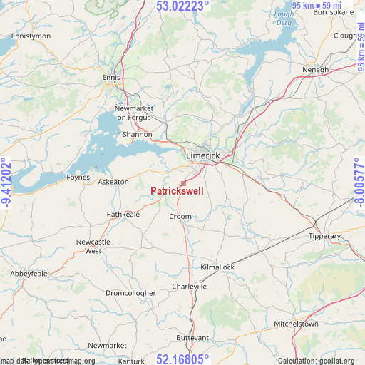
Patrickswell GPS coordinates[2]
52° 35' 49.992" North, 8° 42' 32.004" West
| Map corner | latitude | longitude |
|---|---|---|
| Upper-left | 53.02223°, | -9.41202° |
| Center: | 52.59722°, | -8.70889° |
| Lower-right: | 52.16805°, | -8.00577° |
| Map W x H: | 95×95 km | = 59×59mi |
| max Lat: | 55.25° ⇑76.5% North |
| Patrickswell: | 52.59722° |
| min Lat: | ⇓23.5% South 51.52487° |
| min Long | Patrickswell | max Long |
| -10.26889° | -8.70889° | -6.04944° |
| W 18.4%⇐ | ⇒81.6% E |
Elevation
Elevation of Patrickswell is 24 m = 79 ft, and this is 30.5 m = 100 ft below average elevation for this country.
| Max E: |
262 m = 860 ft | 73.1% |
| Avg. | 54.5 m = 179 ft | |
| Patrickswell | 24 m = 79 ft | |
Min E: |
0 m = 0 ft | 26.9% |
See also: Ireland elevation on elevation.city.
Geographical zone
Patrickswell is located in North temperate zone (between Tropic of Cancer and the Arctic Circle). Distance of this North polar circle is 1552.9 km =964.9 mi to North.| Distance of | km | miles | from Patrickswell |
|---|---|---|---|
| North Pole | 4158.8 | 2584.2 | to North |
| Arctic Circle | 1552.9 | 964.9 | to North |
| Tropic Cancer | 3242.3 | 2014.7 | to South |
| Equator | 5848.3 | 3634 | to South |


Nearby cities:
15 places around Patrickswell: (largest is in red/bold)
• Adare
7 km =4.3 mi,  236°
236°
• Annacotty
14.3 km =8.9 mi,  56°
56°
• Ardnacrusha
14 km =8.7 mi,  27°
27°
• Ballingarry
17.4 km =10.8 mi,  217°
217°
• Ballycannan
12.3 km =7.6 mi,  18°
18°
• Caherconlish
16.1 km =10 mi,  91°
91°
• Clonlara
17.6 km =10.9 mi,  36°
36°
• Cratloe
11.4 km =7.1 mi,  342°
342°
• Croom
8.7 km =5.4 mi,  183°
183°
• Luimneach
9.5 km =5.9 mi, 37°
• Moyross
10.5 km =6.5 mi, 26°
• Pallaskenry
11.9 km =7.4 mi,  295°
295°
• Rathkeale
17.5 km =10.9 mi, 242°
• Shannon
15.8 km =9.8 mi,  318°
318°
• Sixmilebridge
16.6 km =10.3 mi, 344°
Sources, notices
• [Note1] Compared only with cities in Ireland existing in our database
• [Src1] Map data: © OpenStreetMap contributors (CC-BY-SA)
• [Src2] Other city data from geonames.org with taken over terms of usage.
• [Src3] Geographical zone / Annual Mean Temperature by Robert A. Rohde @ Wikipedia
