Croom geodata
Croom (Munster) is a populated place; located in Ireland in Europe/Dublin (GMT+1) time zone. With population of 1,157 people, there are 321 cities with bigger population in this country. Compared to other cities in Ireland, 78.9% of cities are located further ↑North; 81.8% of cities are located further →East and 75% of cities have higher elevation than Croom. Note1


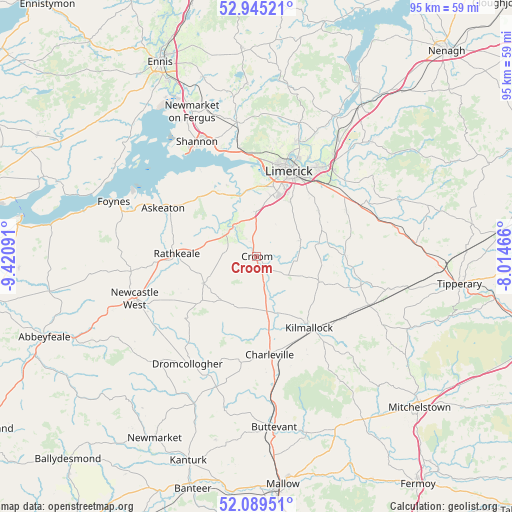
Croom GPS coordinates[2]
52° 31' 9.984" North, 8° 43' 4.008" West
| Map corner | latitude | longitude |
|---|---|---|
| Upper-left | 52.94521°, | -9.42091° |
| Center: | 52.51944°, | -8.71778° |
| Lower-right: | 52.08951°, | -8.01466° |
| Map W x H: | 95.1×95.1 km | = 59.1×59.1mi |
| max Lat: | 55.25° ⇑78.9% North |
| Croom: | 52.51944° |
| min Lat: | ⇓21.1% South 51.52487° |
| min Long | Croom | max Long |
| -10.26889° | -8.71778° | -6.04944° |
| W 18.2%⇐ | ⇒81.8% E |
Elevation
Elevation of Croom is 21 m = 69 ft, and this is 33.5 m = 110 ft below average elevation for this country.
| Max E: |
262 m = 860 ft | 75% |
| Avg. | 54.5 m = 179 ft | |
| Croom | 21 m = 69 ft | |
Min E: |
0 m = 0 ft | 25% |
See also: Ireland elevation on elevation.city.
Geographical zone
Croom is located in North temperate zone (between Tropic of Cancer and the Arctic Circle). Distance of this North polar circle is 1561.6 km =970.3 mi to North.| Distance of | km | miles | from Croom |
|---|---|---|---|
| North Pole | 4167.4 | 2589.5 | to North |
| Arctic Circle | 1561.6 | 970.3 | to North |
| Tropic Cancer | 3233.7 | 2009.3 | to South |
| Equator | 5839.6 | 3628.6 | to South |


Nearby cities:
15 places around Croom: (largest is in red/bold)
• Adare
7.1 km =4.4 mi,  311°
311°
• Askeaton
19.6 km =12.2 mi,  297°
297°
• Ballingarry
11.2 km =7 mi,  242°
242°
• Bruff
12.7 km =7.9 mi,  113°
113°
• Bruree
11.4 km =7.1 mi,  161°
161°
• Caherconlish
18.7 km =11.6 mi,  63°
63°
• Cratloe
19.7 km =12.2 mi,  351°
351°
• Hospital
20.1 km =12.5 mi,  104°
104°
• Kilmallock
16.3 km =10.1 mi,  144°
144°
• Luimneach
17.4 km =10.8 mi,  21°
21°
• Moyross
18.8 km =11.7 mi, 16°
• Pallaskenry
17.1 km =10.6 mi,  323°
323°
• Patrickswell
8.7 km =5.4 mi,  3°
3°
• Rathkeale
14.9 km =9.3 mi,  272°
272°
• Ráth Luirc
19 km =11.8 mi,  172°
172°
Sources, notices
• [Note1] Compared only with cities in Ireland existing in our database
• [Src1] Map data: © OpenStreetMap contributors (CC-BY-SA)
• [Src2] Other city data from geonames.org with taken over terms of usage.
• [Src3] Geographical zone / Annual Mean Temperature by Robert A. Rohde @ Wikipedia
