Caherconlish geodata
Caherconlish (Munster) is a populated place; located in Ireland in Europe/Dublin (GMT+1) time zone. With population of 1,279 people, there are 302 cities with bigger population in this country. Compared to other cities in Ireland, 76.7% of cities are located further ↑North; 73.8% of cities are located further →East and 59.8% of cities have lower elevation than Caherconlish. Note1


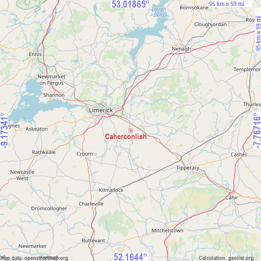
Caherconlish GPS coordinates[2]
52° 35' 36.996" North, 8° 28' 13.008" West
| Map corner | latitude | longitude |
|---|---|---|
| Upper-left | 53.01865°, | -9.17341° |
| Center: | 52.59361°, | -8.47028° |
| Lower-right: | 52.1644°, | -7.76716° |
| Map W x H: | 95×95 km | = 59×59mi |
| max Lat: | 55.25° ⇑76.7% North |
| Caherconlish: | 52.59361° |
| min Lat: | ⇓23.3% South 51.52487° |
| min Long | Caherconlish | max Long |
| -10.26889° | -8.47028° | -6.04944° |
| W 26.2%⇐ | ⇒73.8% E |
Elevation
Elevation of Caherconlish is 60 m = 197 ft, and this is 5.5 m = 18 ft above average elevation for this country.
| Max E: |
262 m = 860 ft | 40.2% |
| Caherconlish | 60 m 197 ft | |
| Avg. | 54.5 m = 179 ft | |
Min E: |
0 m = 0 ft | 59.8% |
See also: Ireland elevation on elevation.city.
Geographical zone
Caherconlish is located in North temperate zone (between Tropic of Cancer and the Arctic Circle). Distance of this North polar circle is 1553.3 km =965.2 mi to North.| Distance of | km | miles | from Caherconlish |
|---|---|---|---|
| North Pole | 4159.2 | 2584.4 | to North |
| Arctic Circle | 1553.3 | 965.2 | to North |
| Tropic Cancer | 3241.9 | 2014.4 | to South |
| Equator | 5847.9 | 3633.7 | to South |


Nearby cities:
15 places around Caherconlish: (largest is in red/bold)
• Annacotty
9.2 km =5.7 mi,  333°
333°
• Ardnacrusha
16.1 km =10 mi,  322°
322°
• Ballycannan
17.1 km =10.6 mi,  314°
314°
• Bruff
14.2 km =8.8 mi,  201°
201°
• Cappamore
9.4 km =5.8 mi,  75°
75°
• Castleconnell
13.5 km =8.4 mi,  351°
351°
• Clonlara
15.6 km =9.7 mi,  339°
339°
• Doon
15.3 km =9.5 mi,  85°
85°
• Hospital
13.7 km =8.5 mi,  168°
168°
• Luimneach
13 km =8.1 mi, 307°
• Moroe
8.1 km =5 mi,  38°
38°
• Moyross
15.1 km =9.4 mi, 310°
• Newport
13.7 km =8.5 mi,  17°
17°
• Pallasgreen
9.4 km =5.8 mi,  107°
107°
• Patrickswell
16.1 km =10 mi,  271°
271°
Sources, notices
• [Note1] Compared only with cities in Ireland existing in our database
• [Src1] Map data: © OpenStreetMap contributors (CC-BY-SA)
• [Src2] Other city data from geonames.org with taken over terms of usage.
• [Src3] Geographical zone / Annual Mean Temperature by Robert A. Rohde @ Wikipedia
