Annacotty geodata
Annacotty (Munster) is a populated place; located in Ireland in Europe/Dublin (GMT+1) time zone. With population of 2,856 people, there are 191 cities with bigger population in this country. Compared to other cities in Ireland, 73.4% of cities are located further ↑North; 76.3% of cities are located further →East and 75.9% of cities have higher elevation than Annacotty. Note1


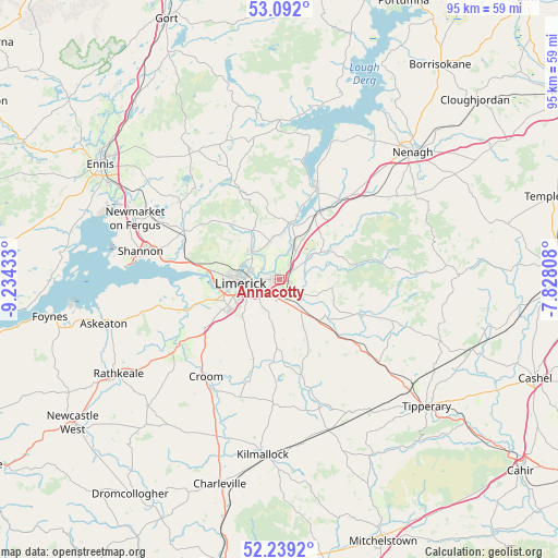
Annacotty GPS coordinates[2]
52° 40' 3.648" North, 8° 31' 52.356" West
| Map corner | latitude | longitude |
|---|---|---|
| Upper-left | 53.092°, | -9.23433° |
| Center: | 52.66768°, | -8.53121° |
| Lower-right: | 52.2392°, | -7.82808° |
| Map W x H: | 94.8×94.8 km | = 58.9×58.9mi |
| max Lat: | 55.25° ⇑73.4% North |
| Annacotty: | 52.66768° |
| min Lat: | ⇓26.6% South 51.52487° |
| min Long | Annacotty | max Long |
| -10.26889° | -8.53121° | -6.04944° |
| W 23.7%⇐ | ⇒76.3% E |
Elevation
Elevation of Annacotty is 20 m = 66 ft, and this is 34.5 m = 113 ft below average elevation for this country.
| Max E: |
262 m = 860 ft | 75.9% |
| Avg. | 54.5 m = 179 ft | |
| Annacotty | 20 m = 66 ft | |
Min E: |
0 m = 0 ft | 24.1% |
See also: Ireland elevation on elevation.city.
Geographical zone
Annacotty is located in North temperate zone (between Tropic of Cancer and the Arctic Circle). Distance of this North polar circle is 1545.1 km =960.1 mi to North.| Distance of | km | miles | from Annacotty |
|---|---|---|---|
| North Pole | 4151 | 2579.3 | to North |
| Arctic Circle | 1545.1 | 960.1 | to North |
| Tropic Cancer | 3250.2 | 2019.6 | to South |
| Equator | 5856.1 | 3638.8 | to South |


Nearby cities:
15 places around Annacotty: (largest is in red/bold)
• Ardnacrusha
7.2 km =4.5 mi,  309°
309°
• Ballina
16.9 km =10.5 mi,  22°
22°
• Ballycannan
8.9 km =5.5 mi,  295°
295°
• Caherconlish
9.2 km =5.7 mi,  153°
153°
• Cappamore
14.5 km =9 mi,  114°
114°
• Castleconnell
5.6 km =3.5 mi, 22°
• Clonlara
6.5 km =4 mi,  347°
347°
• Cratloe
15.7 km =9.8 mi,  281°
281°
• Killaloe
16.5 km =10.3 mi, 20°
• Luimneach
6.2 km =3.9 mi,  266°
266°
• Moroe
9.3 km =5.8 mi,  101°
101°
• Moyross
7.5 km =4.7 mi, 282°
• Newport
9.5 km =5.9 mi,  59°
59°
• Pallasgreen
17.1 km =10.6 mi,  130°
130°
• Patrickswell
14.3 km =8.9 mi,  236°
236°
Sources, notices
• [Note1] Compared only with cities in Ireland existing in our database
• [Src1] Map data: © OpenStreetMap contributors (CC-BY-SA)
• [Src2] Other city data from geonames.org with taken over terms of usage.
• [Src3] Geographical zone / Annual Mean Temperature by Robert A. Rohde @ Wikipedia
