Moycullen geodata
Moycullen (Connaught) is a populated place; located in Ireland in Europe/Dublin (GMT+1) time zone. With population of 1,559 people, there are 264 cities with bigger population in this country. Compared to other cities in Ireland, 59.2% of cities are located further ↓South; 92.2% of cities are located further →East and 63% of cities have higher elevation than Moycullen. Note1


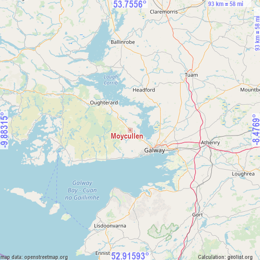
Moycullen GPS coordinates[2]
53° 20' 16.188" North, 9° 10' 48.072" West
| Map corner | latitude | longitude |
|---|---|---|
| Upper-left | 53.7556°, | -9.88315° |
| Center: | 53.33783°, | -9.18002° |
| Lower-right: | 52.91593°, | -8.4769° |
| Map W x H: | 93.4×93.4 km | = 58×58mi |
| max Lat: | 55.25° ⇑40.8% North |
| Moycullen: | 53.33783° |
| min Lat: | ⇓59.2% South 51.52487° |
| min Long | Moycullen | max Long |
| -10.26889° | -9.18002° | -6.04944° |
| W 7.8%⇐ | ⇒92.2% E |
Elevation
Elevation of Moycullen is 33 m = 108 ft, and this is 21.5 m = 71 ft below average elevation for this country.
| Max E: |
262 m = 860 ft | 63% |
| Avg. | 54.5 m = 179 ft | |
| Moycullen | 33 m = 108 ft | |
Min E: |
0 m = 0 ft | 37% |
See also: Ireland elevation on elevation.city.
Geographical zone
Moycullen is located in North temperate zone (between Tropic of Cancer and the Arctic Circle). Distance of this North polar circle is 1470.6 km =913.8 mi to North.| Distance of | km | miles | from Moycullen |
|---|---|---|---|
| North Pole | 4076.5 | 2533 | to North |
| Arctic Circle | 1470.6 | 913.8 | to North |
| Tropic Cancer | 3324.7 | 2065.9 | to South |
| Equator | 5930.6 | 3685.1 | to South |


Nearby cities:
15 places around Moycullen: (largest is in red/bold)
• Athenry
29.4 km =18.3 mi,  99°
99°
• Ballinrobe
33 km =20.5 mi,  353°
353°
• Bearna
9.8 km =6.1 mi,  168°
168°
• Carraroe
29 km =18 mi,  253°
253°
• Claregalway
15.6 km =9.7 mi,  89°
89°
• Corrofin
23.6 km =14.7 mi,  61°
61°
• Craughwell
32.2 km =20 mi,  112°
112°
• Gaillimh
11.4 km =7.1 mi,  130°
130°
• Headford
15.3 km =9.5 mi,  20°
20°
• Kinvarra
27.5 km =17.1 mi,  143°
143°
• Lackagh
20.1 km =12.5 mi,  80°
80°
• Lisdoonvarna
34.7 km =21.6 mi,  192°
192°
• Oranmore
18.9 km =11.7 mi, 114°
• Oughterard
13.4 km =8.3 mi,  310°
310°
• Tuam
29.6 km =18.4 mi,  47°
47°
Sources, notices
• [Note1] Compared only with cities in Ireland existing in our database
• [Src1] Map data: © OpenStreetMap contributors (CC-BY-SA)
• [Src2] Other city data from geonames.org with taken over terms of usage.
• [Src3] Geographical zone / Annual Mean Temperature by Robert A. Rohde @ Wikipedia
