Carraroe geodata
Carraroe (Connaught) is a populated place; located in Ireland in Europe/Dublin (GMT+1) time zone. With population of 814 people, there are 394 cities with bigger population in this country. Compared to other cities in Ireland, 50.3% of cities are located further ↑North; 96.8% of cities are located further →East and 92.6% of cities have higher elevation than Carraroe. Note1


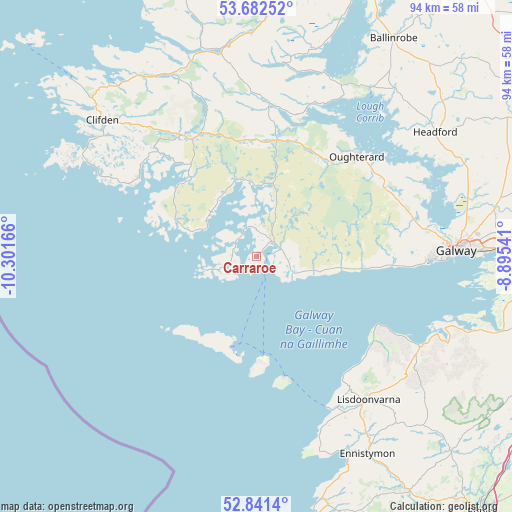
Carraroe GPS coordinates[2]
53° 15' 50.508" North, 9° 35' 54.708" West
| Map corner | latitude | longitude |
|---|---|---|
| Upper-left | 53.68252°, | -10.30166° |
| Center: | 53.26403°, | -9.59853° |
| Lower-right: | 52.8414°, | -8.89541° |
| Map W x H: | 93.5×93.5 km | = 58.1×58.1mi |
| max Lat: | 55.25° ⇑50.3% North |
| Carraroe: | 53.26403° |
| min Lat: | ⇓49.7% South 51.52487° |
| min Long | Carraroe | max Long |
| -10.26889° | -9.59853° | -6.04944° |
| W 3.2%⇐ | ⇒96.8% E |
Elevation
Elevation of Carraroe is 8 m = 26 ft, and this is 46.5 m = 153 ft below average elevation for this country.
| Max E: |
262 m = 860 ft | 92.6% |
| Avg. | 54.5 m = 179 ft | |
| Carraroe | 8 m = 26 ft | |
Min E: |
0 m = 0 ft | 7.4% |
See also: Ireland elevation on elevation.city.
Geographical zone
Carraroe is located in North temperate zone (between Tropic of Cancer and the Arctic Circle). Distance of this North polar circle is 1478.8 km =918.9 mi to North.| Distance of | km | miles | from Carraroe |
|---|---|---|---|
| North Pole | 4084.7 | 2538.1 | to North |
| Arctic Circle | 1478.8 | 918.9 | to North |
| Tropic Cancer | 3316.5 | 2060.8 | to South |
| Equator | 5922.4 | 3680 | to South |


Nearby cities:
15 places around Carraroe: (largest is in red/bold)
• Ballinrobe
47.7 km =29.6 mi,  30°
30°
• Bearna
29.9 km =18.6 mi,  92°
92°
• Claregalway
44.2 km =27.5 mi,  79°
79°
• Clifden
37.5 km =23.3 mi,  311°
311°
• Ennistimon
41 km =25.5 mi,  150°
150°
• Gaillimh
36.6 km =22.7 mi, 88°
• Headford
40 km =24.9 mi,  55°
55°
• Kinvarra
46.4 km =28.8 mi,  107°
107°
• Lackagh
49.1 km =30.5 mi, 76°
• Lehinch
40.8 km =25.4 mi, 154°
• Lisdoonvarna
33 km =20.5 mi,  141°
141°
• Miltown Malbay
47.4 km =29.5 mi,  163°
163°
• Moycullen
29 km =18 mi,  73°
73°
• Oranmore
45.1 km =28 mi, 89°
• Oughterard
24.5 km =15.2 mi,  46°
46°
Sources, notices
• [Note1] Compared only with cities in Ireland existing in our database
• [Src1] Map data: © OpenStreetMap contributors (CC-BY-SA)
• [Src2] Other city data from geonames.org with taken over terms of usage.
• [Src3] Geographical zone / Annual Mean Temperature by Robert A. Rohde @ Wikipedia
