Lisdoonvarna geodata
Lisdoonvarna (Munster) is a populated place; located in Ireland in Europe/Dublin (GMT+1) time zone. With population of 739 people, there are 421 cities with bigger population in this country. Compared to other cities in Ireland, 60.2% of cities are located further ↑North; 93.4% of cities are located further →East and 89.9% of cities have lower elevation than Lisdoonvarna. Note1


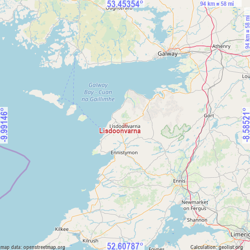
Lisdoonvarna GPS coordinates[2]
53° 1' 58.008" North, 9° 17' 17.988" West
| Map corner | latitude | longitude |
|---|---|---|
| Upper-left | 53.45354°, | -9.99146° |
| Center: | 53.03278°, | -9.28833° |
| Lower-right: | 52.60787°, | -8.58521° |
| Map W x H: | 94×94 km | = 58.4×58.4mi |
| max Lat: | 55.25° ⇑60.2% North |
| Lisdoonvarna: | 53.03278° |
| min Lat: | ⇓39.8% South 51.52487° |
| min Long | Lisdoonvarna | max Long |
| -10.26889° | -9.28833° | -6.04944° |
| W 6.6%⇐ | ⇒93.4% E |
Elevation
Elevation of Lisdoonvarna is 104 m = 341 ft, and this is 49.5 m = 162 ft above average elevation for this country.
| Max E: |
262 m = 860 ft | 10.1% |
| Lisdoonvarna | 104 m 341 ft | |
| Avg. | 54.5 m = 179 ft | |
Min E: |
0 m = 0 ft | 89.9% |
See also: Ireland elevation on elevation.city.
Geographical zone
Lisdoonvarna is located in North temperate zone (between Tropic of Cancer and the Arctic Circle). Distance of this North polar circle is 1504.5 km =934.9 mi to North.| Distance of | km | miles | from Lisdoonvarna |
|---|---|---|---|
| North Pole | 4110.4 | 2554.1 | to North |
| Arctic Circle | 1504.5 | 934.9 | to North |
| Tropic Cancer | 3290.8 | 2044.8 | to South |
| Equator | 5896.7 | 3664 | to South |


Nearby cities:
15 places around Lisdoonvarna: (largest is in red/bold)
• Bearna
26.1 km =16.2 mi,  20°
20°
• Boston
23.8 km =14.8 mi,  90°
90°
• Carraroe
33 km =20.5 mi,  321°
321°
• Corofin
17.8 km =11.1 mi,  122°
122°
• Ennis
29.2 km =18.1 mi,  136°
136°
• Ennistimon
9.8 km =6.1 mi,  181°
181°
• Gaillimh
31 km =19.3 mi,  30°
30°
• Gort
31.7 km =19.7 mi,  83°
83°
• Kinvarra
26.5 km =16.5 mi,  63°
63°
• Lehinch
11.6 km =7.2 mi,  196°
196°
• Miltown Malbay
21.1 km =13.1 mi, 200°
• Moycullen
34.7 km =21.6 mi,  12°
12°
• Oranmore
35.9 km =22.3 mi,  43°
43°
• Quin
36.9 km =22.9 mi,  130°
130°
• Tulla
40 km =24.9 mi, 117°
Sources, notices
• [Note1] Compared only with cities in Ireland existing in our database
• [Src1] Map data: © OpenStreetMap contributors (CC-BY-SA)
• [Src2] Other city data from geonames.org with taken over terms of usage.
• [Src3] Geographical zone / Annual Mean Temperature by Robert A. Rohde @ Wikipedia
