Loughrea geodata
Loughrea (Connaught) is a populated place; located in Ireland in Europe/Dublin (GMT+1) time zone. With population of 5,062 people, there are 134 cities with bigger population in this country. Compared to other cities in Ireland, 53.3% of cities are located further ↑North; 77.6% of cities are located further →East and 77.4% of cities have lower elevation than Loughrea. Note1


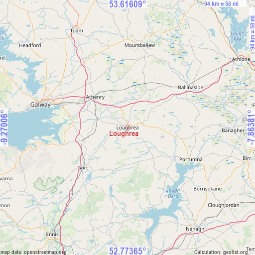
Loughrea GPS coordinates[2]
53° 11' 48.984" North, 8° 34' 0.984" West
| Map corner | latitude | longitude |
|---|---|---|
| Upper-left | 53.61609°, | -9.27006° |
| Center: | 53.19694°, | -8.56694° |
| Lower-right: | 52.77365°, | -7.86381° |
| Map W x H: | 93.7×93.7 km | = 58.2×58.2mi |
| max Lat: | 55.25° ⇑53.3% North |
| Loughrea: | 53.19694° |
| min Lat: | ⇓46.7% South 51.52487° |
| min Long | Loughrea | max Long |
| -10.26889° | -8.56694° | -6.04944° |
| W 22.4%⇐ | ⇒77.6% E |
Elevation
Elevation of Loughrea is 84 m = 276 ft, and this is 29.5 m = 97 ft above average elevation for this country.
| Max E: |
262 m = 860 ft | 22.6% |
| Loughrea | 84 m 276 ft | |
| Avg. | 54.5 m = 179 ft | |
Min E: |
0 m = 0 ft | 77.4% |
See also: Ireland elevation on elevation.city.
Geographical zone
Loughrea is located in North temperate zone (between Tropic of Cancer and the Arctic Circle). Distance of this North polar circle is 1486.2 km =923.5 mi to North.| Distance of | km | miles | from Loughrea |
|---|---|---|---|
| North Pole | 4092.1 | 2542.7 | to North |
| Arctic Circle | 1486.2 | 923.5 | to North |
| Tropic Cancer | 3309 | 2056.1 | to South |
| Equator | 5914.9 | 3675.3 | to South |


Nearby cities:
15 places around Loughrea: (largest is in red/bold)
• Athenry
16.1 km =10 mi,  313°
313°
• Ballinasloe
27.3 km =17 mi,  57°
57°
• Boston
30.6 km =19 mi,  232°
232°
• Claregalway
29.7 km =18.5 mi,  302°
302°
• Corrofin
33.4 km =20.8 mi,  323°
323°
• Craughwell
11.5 km =7.1 mi,  286°
286°
• Gaillimh
33.1 km =20.6 mi,  284°
284°
• Gort
22.1 km =13.7 mi, 228°
• Kinvarra
25.3 km =15.7 mi,  255°
255°
• Lackagh
28.1 km =17.5 mi, 312°
• Mountbellew
30.8 km =19.1 mi,  7°
7°
• Moylough
31.8 km =19.8 mi,  0°
0°
• Oranmore
24.8 km =15.4 mi, 288°
• Portumna
26.1 km =16.2 mi,  117°
117°
• Scarriff
32.1 km =19.9 mi,  175°
175°
Sources, notices
• [Note1] Compared only with cities in Ireland existing in our database
• [Src1] Map data: © OpenStreetMap contributors (CC-BY-SA)
• [Src2] Other city data from geonames.org with taken over terms of usage.
• [Src3] Geographical zone / Annual Mean Temperature by Robert A. Rohde @ Wikipedia
