Moylough geodata
Moylough (Connaught) is a populated place; located in Ireland in Europe/Dublin (GMT+1) time zone. With population of 503 people, there are 523 cities with bigger population in this country. Compared to other cities in Ireland, 71% of cities are located further ↓South; 77.4% of cities are located further →East and 73.8% of cities have lower elevation than Moylough. Note1


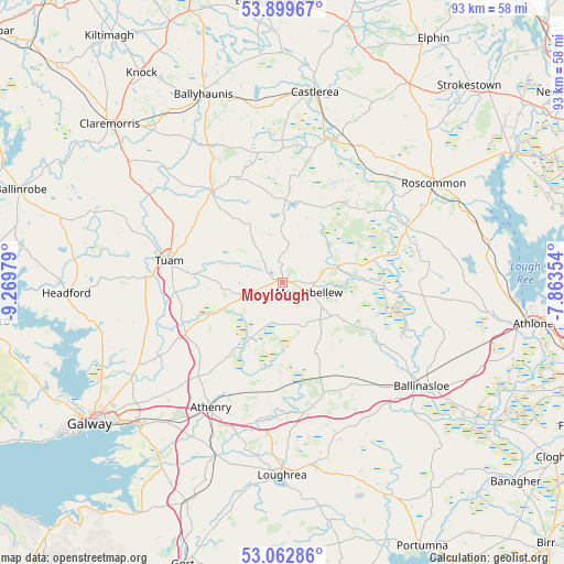
Moylough GPS coordinates[2]
53° 28' 59.988" North, 8° 34' 0.012" West
| Map corner | latitude | longitude |
|---|---|---|
| Upper-left | 53.89967°, | -9.26979° |
| Center: | 53.48333°, | -8.56667° |
| Lower-right: | 53.06286°, | -7.86354° |
| Map W x H: | 93×93 km | = 57.8×57.8mi |
| max Lat: | 55.25° ⇑29% North |
| Moylough: | 53.48333° |
| min Lat: | ⇓71% South 51.52487° |
| min Long | Moylough | max Long |
| -10.26889° | -8.56667° | -6.04944° |
| W 22.6%⇐ | ⇒77.4% E |
Elevation
Elevation of Moylough is 77 m = 253 ft, and this is 22.5 m = 74 ft above average elevation for this country.
| Max E: |
262 m = 860 ft | 26.2% |
| Moylough | 77 m 253 ft | |
| Avg. | 54.5 m = 179 ft | |
Min E: |
0 m = 0 ft | 73.8% |
See also: Ireland elevation on elevation.city.
Geographical zone
Moylough is located in North temperate zone (between Tropic of Cancer and the Arctic Circle). Distance of this North polar circle is 1454.4 km =903.7 mi to North.| Distance of | km | miles | from Moylough |
|---|---|---|---|
| North Pole | 4060.3 | 2523 | to North |
| Arctic Circle | 1454.4 | 903.7 | to North |
| Tropic Cancer | 3340.9 | 2075.9 | to South |
| Equator | 5946.8 | 3695.2 | to South |


Nearby cities:
15 places around Moylough: (largest is in red/bold)
• Athenry
23.9 km =14.9 mi,  209°
209°
• Ballinasloe
28.8 km =17.9 mi,  126°
126°
• Ballygar
16.4 km =10.2 mi,  74°
74°
• Ballyhaunis
34.2 km =21.3 mi,  337°
337°
• Castlerea
31.8 km =19.8 mi,  7°
7°
• Claregalway
29.8 km =18.5 mi,  237°
237°
• Corrofin
20.5 km =12.7 mi,  255°
255°
• Craughwell
30.7 km =19.1 mi,  201°
201°
• Dunmore
18.5 km =11.5 mi,  323°
323°
• Lackagh
24.5 km =15.2 mi, 238°
• Loughrea
31.8 km =19.8 mi,  180°
180°
• Mountbellew
4.3 km =2.7 mi,  107°
107°
• Oranmore
33.5 km =20.8 mi,  224°
224°
• Roscommon
30.3 km =18.8 mi,  56°
56°
• Tuam
19.1 km =11.9 mi,  281°
281°
Sources, notices
• [Note1] Compared only with cities in Ireland existing in our database
• [Src1] Map data: © OpenStreetMap contributors (CC-BY-SA)
• [Src2] Other city data from geonames.org with taken over terms of usage.
• [Src3] Geographical zone / Annual Mean Temperature by Robert A. Rohde @ Wikipedia
