Scarriff geodata
Scarriff (Munster) is a populated place; located in Ireland in Europe/Dublin (GMT+1) time zone. With population of 816 people, there are 392 cities with bigger population in this country. Compared to other cities in Ireland, 64.5% of cities are located further ↑North; 76.5% of cities are located further →East and 59.4% of cities have higher elevation than Scarriff. Note1


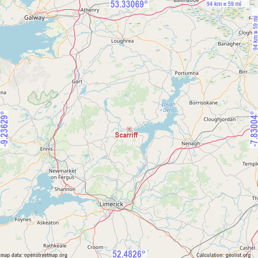
Scarriff GPS coordinates[2]
52° 54' 31.392" North, 8° 31' 59.376" West
| Map corner | latitude | longitude |
|---|---|---|
| Upper-left | 53.33069°, | -9.23629° |
| Center: | 52.90872°, | -8.53316° |
| Lower-right: | 52.4826°, | -7.83004° |
| Map W x H: | 94.3×94.3 km | = 58.6×58.6mi |
| max Lat: | 55.25° ⇑64.5% North |
| Scarriff: | 52.90872° |
| min Lat: | ⇓35.5% South 51.52487° |
| min Long | Scarriff | max Long |
| -10.26889° | -8.53316° | -6.04944° |
| W 23.5%⇐ | ⇒76.5% E |
Elevation
Elevation of Scarriff is 38 m = 125 ft, and this is 16.5 m = 54 ft below average elevation for this country.
| Max E: |
262 m = 860 ft | 59.4% |
| Avg. | 54.5 m = 179 ft | |
| Scarriff | 38 m = 125 ft | |
Min E: |
0 m = 0 ft | 40.6% |
See also: Ireland elevation on elevation.city.
Geographical zone
Scarriff is located in North temperate zone (between Tropic of Cancer and the Arctic Circle). Distance of this North polar circle is 1518.3 km =943.4 mi to North.| Distance of | km | miles | from Scarriff |
|---|---|---|---|
| North Pole | 4124.2 | 2562.7 | to North |
| Arctic Circle | 1518.3 | 943.4 | to North |
| Tropic Cancer | 3277 | 2036.2 | to South |
| Equator | 5882.9 | 3655.5 | to South |


Nearby cities:
15 places around Scarriff: (largest is in red/bold)
• Ardnacrusha
22.9 km =14.2 mi,  193°
193°
• Ballina
13 km =8.1 mi,  149°
149°
• Ballycannan
24.3 km =15.1 mi,  198°
198°
• Castleconnell
21.8 km =13.5 mi,  174°
174°
• Clonlara
20.5 km =12.7 mi,  183°
183°
• Gort
25.8 km =16 mi,  312°
312°
• Kilkishen
18.2 km =11.3 mi,  231°
231°
• Killaloe
12.8 km =8 mi, 152°
• Moyross
26.2 km =16.3 mi, 195°
• Nenagh
23.2 km =14.4 mi,  102°
102°
• Nenagh Bridge
22.8 km =14.2 mi, 97°
• Newport
23.5 km =14.6 mi,  159°
159°
• Quin
24.5 km =15.2 mi,  245°
245°
• Sixmilebridge
24.7 km =15.3 mi,  221°
221°
• Tulla
16 km =9.9 mi, 252°
Sources, notices
• [Note1] Compared only with cities in Ireland existing in our database
• [Src1] Map data: © OpenStreetMap contributors (CC-BY-SA)
• [Src2] Other city data from geonames.org with taken over terms of usage.
• [Src3] Geographical zone / Annual Mean Temperature by Robert A. Rohde @ Wikipedia
