Kilkishen geodata
Kilkishen (Munster) is a populated place; located in Ireland in Europe/Dublin (GMT+1) time zone. With population of 520 people, there are 514 cities with bigger population in this country. Compared to other cities in Ireland, 67.9% of cities are located further ↑North; 83.3% of cities are located further →East and 65.3% of cities have higher elevation than Kilkishen. Note1


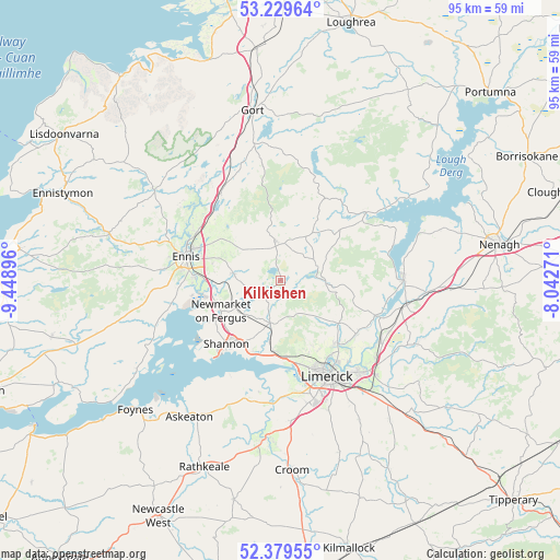
Kilkishen GPS coordinates[2]
52° 48' 24.012" North, 8° 44' 44.988" West
| Map corner | latitude | longitude |
|---|---|---|
| Upper-left | 53.22964°, | -9.44896° |
| Center: | 52.80667°, | -8.74583° |
| Lower-right: | 52.37955°, | -8.04271° |
| Map W x H: | 94.5×94.5 km | = 58.7×58.7mi |
| max Lat: | 55.25° ⇑67.9% North |
| Kilkishen: | 52.80667° |
| min Lat: | ⇓32.1% South 51.52487° |
| min Long | Kilkishen | max Long |
| -10.26889° | -8.74583° | -6.04944° |
| W 16.7%⇐ | ⇒83.3% E |
Elevation
Elevation of Kilkishen is 31 m = 102 ft, and this is 23.5 m = 77 ft below average elevation for this country.
| Max E: |
262 m = 860 ft | 65.3% |
| Avg. | 54.5 m = 179 ft | |
| Kilkishen | 31 m = 102 ft | |
Min E: |
0 m = 0 ft | 34.7% |
See also: Ireland elevation on elevation.city.
Geographical zone
Kilkishen is located in North temperate zone (between Tropic of Cancer and the Arctic Circle). Distance of this North polar circle is 1529.6 km =950.4 mi to North.| Distance of | km | miles | from Kilkishen |
|---|---|---|---|
| North Pole | 4135.5 | 2569.7 | to North |
| Arctic Circle | 1529.6 | 950.4 | to North |
| Tropic Cancer | 3265.6 | 2029.1 | to South |
| Equator | 5871.6 | 3648.4 | to South |


Nearby cities:
15 places around Kilkishen: (largest is in red/bold)
• Ardnacrusha
14 km =8.7 mi,  140°
140°
• Ballycannan
13.3 km =8.3 mi,  151°
151°
• Castleconnell
19.5 km =12.1 mi,  121°
121°
• Clonlara
15.9 km =9.9 mi,  125°
125°
• Cratloe
12.5 km =7.8 mi,  184°
184°
• Ennis
16.7 km =10.4 mi,  284°
284°
• Luimneach
17.8 km =11.1 mi, 152°
• Moyross
15.6 km =9.7 mi, 152°
• Newmarket on Fergus
11.3 km =7 mi,  242°
242°
• Pallaskenry
20 km =12.4 mi,  204°
204°
• Quin
8.2 km =5.1 mi, 279°
• Scarriff
18.2 km =11.3 mi,  51°
51°
• Shannon
13.9 km =8.6 mi,  214°
214°
• Sixmilebridge
7.5 km =4.7 mi,  194°
194°
• Tulla
6.5 km =4 mi,  351°
351°
Sources, notices
• [Note1] Compared only with cities in Ireland existing in our database
• [Src1] Map data: © OpenStreetMap contributors (CC-BY-SA)
• [Src2] Other city data from geonames.org with taken over terms of usage.
• [Src3] Geographical zone / Annual Mean Temperature by Robert A. Rohde @ Wikipedia
