Newmarket on Fergus geodata
Newmarket on Fergus (Munster) is a populated place; located in Ireland in Europe/Dublin (GMT+1) time zone. With population of 1,773 people, there are 246 cities with bigger population in this country. Compared to other cities in Ireland, 69.3% of cities are located further ↑North; 86.3% of cities are located further →East and 80.5% of cities have higher elevation than Newmarket on Fergus. Note1


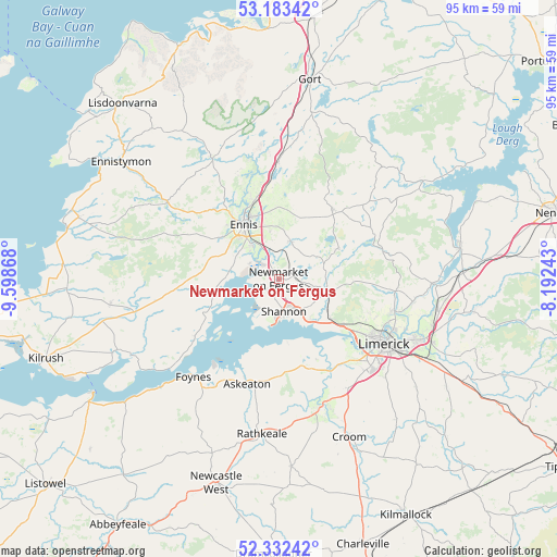
Newmarket on Fergus GPS coordinates[2]
52° 45' 36" North, 8° 53' 44.016" West
| Map corner | latitude | longitude |
|---|---|---|
| Upper-left | 53.18342°, | -9.59868° |
| Center: | 52.76°, | -8.89556° |
| Lower-right: | 52.33242°, | -8.19243° |
| Map W x H: | 94.6×94.6 km | = 58.8×58.8mi |
| max Lat: | 55.25° ⇑69.3% North |
| Newmarket on Fergus: | 52.76° |
| min Lat: | ⇓30.7% South 51.52487° |
| min Long | Newmarket on Fe | max Long |
| -10.26889° | -8.89556° | -6.04944° |
| W 13.7%⇐ | ⇒86.3% E |
Elevation
Elevation of Newmarket on Fergus is 17 m = 56 ft, and this is 37.5 m = 123 ft below average elevation for this country.
| Max E: |
262 m = 860 ft | 80.5% |
| Avg. | 54.5 m = 179 ft | |
| Newmarket on Fergus | 17 m = 56 ft | |
Min E: |
0 m = 0 ft | 19.5% |
See also: Ireland elevation on elevation.city.
Geographical zone
Newmarket on Fergus is located in North temperate zone (between Tropic of Cancer and the Arctic Circle). Distance of this North polar circle is 1534.8 km =953.7 mi to North.| Distance of | km | miles | from Newmarket on Fergus |
|---|---|---|---|
| North Pole | 4140.7 | 2572.9 | to North |
| Arctic Circle | 1534.8 | 953.7 | to North |
| Tropic Cancer | 3260.4 | 2025.9 | to South |
| Equator | 5866.4 | 3645.2 | to South |


Nearby cities:
15 places around Newmarket on Fergus: (largest is in red/bold)
• Ardnacrusha
19.8 km =12.3 mi,  106°
106°
• Askeaton
18.6 km =11.6 mi,  196°
196°
• Ballycannan
17.7 km =11 mi, 111°
• Cratloe
11.7 km =7.3 mi,  128°
128°
• Ennis
11.1 km =6.9 mi,  326°
326°
• Foynes
22 km =13.7 mi,  221°
221°
• Kilkishen
11.3 km =7 mi,  62°
62°
• Luimneach
21.2 km =13.2 mi,  119°
119°
• Moyross
19.3 km =12 mi, 116°
• Pallaskenry
13.1 km =8.1 mi,  172°
172°
• Patrickswell
22 km =13.7 mi,  145°
145°
• Quin
6.8 km =4.2 mi,  16°
16°
• Shannon
6.6 km =4.1 mi,  161°
161°
• Sixmilebridge
8.4 km =5.2 mi,  104°
104°
• Tulla
14.8 km =9.2 mi,  37°
37°
Sources, notices
• [Note1] Compared only with cities in Ireland existing in our database
• [Src1] Map data: © OpenStreetMap contributors (CC-BY-SA)
• [Src2] Other city data from geonames.org with taken over terms of usage.
• [Src3] Geographical zone / Annual Mean Temperature by Robert A. Rohde @ Wikipedia
