Charlesland geodata
Charlesland (Leinster) is a populated place; located in Ireland in Europe/Dublin (GMT+1) time zone. With population of 1,800 people, there are 243 cities with bigger population in this country. Compared to other cities in Ireland, 56.9% of cities are located further ↑North; 99.6% of cities are located further ←West and 86.3% of cities have higher elevation than Charlesland. Note1


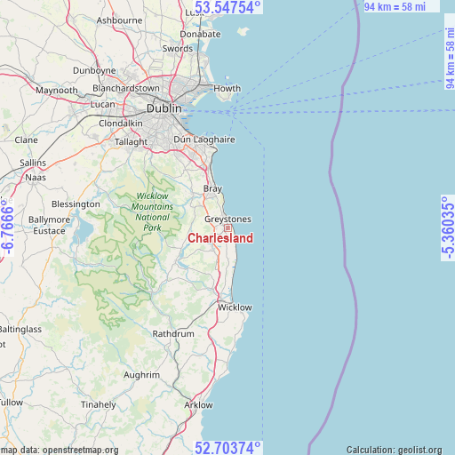
Charlesland GPS coordinates[2]
53° 7' 39.756" North, 6° 3' 48.492" West
| Map corner | latitude | longitude |
|---|---|---|
| Upper-left | 53.54754°, | -6.7666° |
| Center: | 53.12771°, | -6.06347° |
| Lower-right: | 52.70374°, | -5.36035° |
| Map W x H: | 93.8×93.8 km | = 58.3×58.3mi |
| max Lat: | 55.25° ⇑56.9% North |
| Charlesland: | 53.12771° |
| min Lat: | ⇓43.1% South 51.52487° |
| min Long | Charlesland | max Long |
| -10.26889° | -6.06347° | -6.04944° |
| W 99.6%⇐ | ⇒0.40000000000001% E |
Elevation
Elevation of Charlesland is 12 m = 39 ft, and this is 42.5 m = 139 ft below average elevation for this country.
| Max E: |
262 m = 860 ft | 86.3% |
| Avg. | 54.5 m = 179 ft | |
| Charlesland | 12 m = 39 ft | |
Min E: |
0 m = 0 ft | 13.7% |
See also: Ireland elevation on elevation.city.
Geographical zone
Charlesland is located in North temperate zone (between Tropic of Cancer and the Arctic Circle). Distance of this North polar circle is 1493.9 km =928.3 mi to North.| Distance of | km | miles | from Charlesland |
|---|---|---|---|
| North Pole | 4099.8 | 2547.5 | to North |
| Arctic Circle | 1493.9 | 928.3 | to North |
| Tropic Cancer | 3301.3 | 2051.3 | to South |
| Equator | 5907.2 | 3670.6 | to South |


Nearby cities:
15 places around Charlesland: (largest is in red/bold)
• Ashford
13.7 km =8.5 mi,  193°
193°
• Bray
8.7 km =5.4 mi,  344°
344°
• Enniskerry
10.1 km =6.3 mi,  315°
315°
• Greystones
1.5 km =0.9 mi,  1°
1°
• Kilcoole
2.8 km =1.7 mi,  182°
182°
• Kilmacanoge
6.4 km =4 mi,  313°
313°
• Kilpedder
3.5 km =2.2 mi,  234°
234°
• Kilquade
3.6 km =2.2 mi,  202°
202°
• Little Bray
9.3 km =5.8 mi, 335°
• Loughlinstown
13.7 km =8.5 mi, 340°
• Newcastle
6.6 km =4.1 mi, 181°
• Newtownmountkennedy
5.2 km =3.2 mi,  217°
217°
• Rathnew
15.3 km =9.5 mi, 185°
• Roundwood
13.3 km =8.3 mi, 234°
• Shankill
11.7 km =7.3 mi, 339°
Sources, notices
• [Note1] Compared only with cities in Ireland existing in our database
• [Src1] Map data: © OpenStreetMap contributors (CC-BY-SA)
• [Src2] Other city data from geonames.org with taken over terms of usage.
• [Src3] Geographical zone / Annual Mean Temperature by Robert A. Rohde @ Wikipedia
