Dundrum geodata
Dundrum (Leinster) is a populated place; located in Ireland in Europe/Dublin (GMT+1) time zone. With population of 12,152 people, there are 43 cities with bigger population in this country. Compared to other cities in Ireland, 54.1% of cities are located further ↓South; 86.1% of cities are located further ←West and 59.8% of cities have lower elevation than Dundrum. Note1


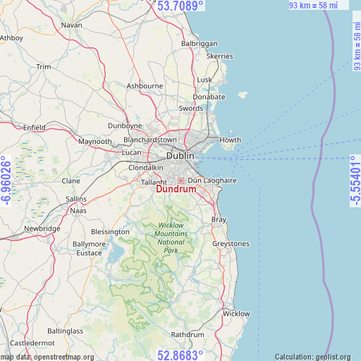
Dundrum GPS coordinates[2]
53° 17' 26.412" North, 6° 15' 25.704" West
| Map corner | latitude | longitude |
|---|---|---|
| Upper-left | 53.7089°, | -6.96026° |
| Center: | 53.29067°, | -6.25714° |
| Lower-right: | 52.8683°, | -5.55401° |
| Map W x H: | 93.5×93.5 km | = 58.1×58.1mi |
| max Lat: | 55.25° ⇑45.9% North |
| Dundrum: | 53.29067° |
| min Lat: | ⇓54.1% South 51.52487° |
| min Long | Dundrum | max Long |
| -10.26889° | -6.25714° | -6.04944° |
| W 86.1%⇐ | ⇒13.9% E |
Elevation
Elevation of Dundrum is 60 m = 197 ft, and this is 5.5 m = 18 ft above average elevation for this country.
| Max E: |
262 m = 860 ft | 40.2% |
| Dundrum | 60 m 197 ft | |
| Avg. | 54.5 m = 179 ft | |
Min E: |
0 m = 0 ft | 59.8% |
See also: Ireland elevation on elevation.city.
Geographical zone
Dundrum is located in North temperate zone (between Tropic of Cancer and the Arctic Circle). Distance of this North polar circle is 1475.8 km =917 mi to North.| Distance of | km | miles | from Dundrum |
|---|---|---|---|
| North Pole | 4081.7 | 2536.3 | to North |
| Arctic Circle | 1475.8 | 917 | to North |
| Tropic Cancer | 3319.4 | 2062.6 | to South |
| Equator | 5925.4 | 3681.9 | to South |


Nearby cities:
15 places around Dundrum: (largest is in red/bold)
• Balally
2.2 km =1.4 mi,  140°
140°
• Ballinteer
1.9 km =1.2 mi,  173°
173°
• Ballyboden
4.1 km =2.5 mi,  254°
254°
• Booterstown
4.1 km =2.5 mi,  68°
68°
• Clonskeagh
3.2 km =2 mi,  32°
32°
• Donnybrook
3.4 km =2.1 mi,  41°
41°
• Dublin
4.7 km =2.9 mi,  6°
6°
• Milltown
2.6 km =1.6 mi,  17°
17°
• Mount Merrion
3 km =1.9 mi, 69°
• Rathgar
2.9 km =1.8 mi,  335°
335°
• Rathmines
3.3 km =2.1 mi,  352°
352°
• Sandyford
2.8 km =1.7 mi,  129°
129°
• Sandymount
4.8 km =3 mi, 29°
• Templeogue
3.5 km =2.2 mi,  278°
278°
• Terenure
2.8 km =1.7 mi,  318°
318°
Sources, notices
• [Note1] Compared only with cities in Ireland existing in our database
• [Src1] Map data: © OpenStreetMap contributors (CC-BY-SA)
• [Src2] Other city data from geonames.org with taken over terms of usage.
• [Src3] Geographical zone / Annual Mean Temperature by Robert A. Rohde @ Wikipedia
