Sandymount geodata
Sandymount (Leinster) is a populated place; located in Ireland in Europe/Dublin (GMT+1) time zone. With population of 8,967 people, there are 69 cities with bigger population in this country. Compared to other cities in Ireland, 58.3% of cities are located further ↓South; 89.6% of cities are located further ←West and 99.8% of cities have higher elevation than Sandymount. Note1


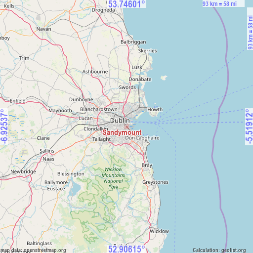
Sandymount GPS coordinates[2]
53° 19' 41.34" North, 6° 13' 20.064" West
| Map corner | latitude | longitude |
|---|---|---|
| Upper-left | 53.74601°, | -6.92537° |
| Center: | 53.32815°, | -6.22224° |
| Lower-right: | 52.90615°, | -5.51912° |
| Map W x H: | 93.4×93.4 km | = 58×58mi |
| max Lat: | 55.25° ⇑41.7% North |
| Sandymount: | 53.32815° |
| min Lat: | ⇓58.3% South 51.52487° |
| min Long | Sandymount | max Long |
| -10.26889° | -6.22224° | -6.04944° |
| W 89.6%⇐ | ⇒10.4% E |
Elevation
Elevation of Sandymount is 1 m = 3 ft, and this is 53.5 m = 176 ft below average elevation for this country.
| Max E: |
262 m = 860 ft | 99.8% |
| Avg. | 54.5 m = 179 ft | |
| Sandymount | 1 m = 3 ft | |
Min E: |
0 m = 0 ft | 0.2% |
See also: Ireland elevation on elevation.city.
Geographical zone
Sandymount is located in North temperate zone (between Tropic of Cancer and the Arctic Circle). Distance of this North polar circle is 1471.6 km =914.4 mi to North.| Distance of | km | miles | from Sandymount |
|---|---|---|---|
| North Pole | 4077.5 | 2533.6 | to North |
| Arctic Circle | 1471.6 | 914.4 | to North |
| Tropic Cancer | 3323.6 | 2065.2 | to South |
| Equator | 5929.5 | 3684.4 | to South |


Nearby cities:
15 places around Sandymount: (largest is in red/bold)
• Blackrock
4.2 km =2.6 mi,  135°
135°
• Booterstown
3 km =1.9 mi,  150°
150°
• Clonskeagh
1.6 km =1 mi,  202°
202°
• Dollymount
4.9 km =3 mi,  34°
34°
• Donnybrook
1.6 km =1 mi,  181°
181°
• Dublin
1.9 km =1.2 mi,  287°
287°
• Dundrum
4.8 km =3 mi,  209°
209°
• Fairview
4.4 km =2.7 mi,  344°
344°
• Marino
4.8 km =3 mi,  348°
348°
• Milltown
2.3 km =1.4 mi,  222°
222°
• Mount Merrion
3.2 km =2 mi,  171°
171°
• Rathgar
3.8 km =2.4 mi,  246°
246°
• Rathmines
2.9 km =1.8 mi, 252°
• Ringsend
1.6 km =1 mi, 349°
• Terenure
4.7 km =2.9 mi,  243°
243°
Sources, notices
• [Note1] Compared only with cities in Ireland existing in our database
• [Src1] Map data: © OpenStreetMap contributors (CC-BY-SA)
• [Src2] Other city data from geonames.org with taken over terms of usage.
• [Src3] Geographical zone / Annual Mean Temperature by Robert A. Rohde @ Wikipedia
