Donnybrook geodata
Donnybrook (Leinster) is a populated place; located in Ireland in Europe/Dublin (GMT+1) time zone. With population of 10,645 people, there are 52 cities with bigger population in this country. Compared to other cities in Ireland, 56.7% of cities are located further ↓South; 89.4% of cities are located further ←West and 80.5% of cities have higher elevation than Donnybrook. Note1


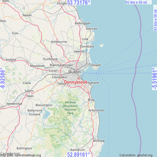
Donnybrook GPS coordinates[2]
53° 18' 49.5" North, 6° 13' 21.864" West
| Map corner | latitude | longitude |
|---|---|---|
| Upper-left | 53.73176°, | -6.92586° |
| Center: | 53.31375°, | -6.22274° |
| Lower-right: | 52.89161°, | -5.51961° |
| Map W x H: | 93.4×93.4 km | = 58×58mi |
| max Lat: | 55.25° ⇑43.3% North |
| Donnybrook: | 53.31375° |
| min Lat: | ⇓56.7% South 51.52487° |
| min Long | Donnybrook | max Long |
| -10.26889° | -6.22274° | -6.04944° |
| W 89.4%⇐ | ⇒10.6% E |
Elevation
Elevation of Donnybrook is 17 m = 56 ft, and this is 37.5 m = 123 ft below average elevation for this country.
| Max E: |
262 m = 860 ft | 80.5% |
| Avg. | 54.5 m = 179 ft | |
| Donnybrook | 17 m = 56 ft | |
Min E: |
0 m = 0 ft | 19.5% |
See also: Ireland elevation on elevation.city.
Geographical zone
Donnybrook is located in North temperate zone (between Tropic of Cancer and the Arctic Circle). Distance of this North polar circle is 1473.2 km =915.4 mi to North.| Distance of | km | miles | from Donnybrook |
|---|---|---|---|
| North Pole | 4079.1 | 2534.6 | to North |
| Arctic Circle | 1473.2 | 915.4 | to North |
| Tropic Cancer | 3322 | 2064.2 | to South |
| Equator | 5927.9 | 3683.4 | to South |


Nearby cities:
15 places around Donnybrook: (largest is in red/bold)
• Balally
4.4 km =2.7 mi,  191°
191°
• Ballinteer
4.9 km =3 mi,  205°
205°
• Blackrock
3.3 km =2.1 mi,  114°
114°
• Booterstown
1.8 km =1.1 mi,  124°
124°
• Clonskeagh
0.6 km =0.4 mi,  279°
279°
• Dublin
2.8 km =1.7 mi,  321°
321°
• Dundrum
3.4 km =2.1 mi,  221°
221°
• Milltown
1.5 km =0.9 mi,  266°
266°
• Mount Merrion
1.6 km =1 mi,  161°
161°
• Rathgar
3.5 km =2.2 mi, 271°
• Rathmines
2.8 km =1.7 mi,  285°
285°
• Ringsend
3.1 km =1.9 mi,  355°
355°
• Sandyford
4.3 km =2.7 mi,  182°
182°
• Sandymount
1.6 km =1 mi,  1°
1°
• Terenure
4.2 km =2.6 mi,  263°
263°
Sources, notices
• [Note1] Compared only with cities in Ireland existing in our database
• [Src1] Map data: © OpenStreetMap contributors (CC-BY-SA)
• [Src2] Other city data from geonames.org with taken over terms of usage.
• [Src3] Geographical zone / Annual Mean Temperature by Robert A. Rohde @ Wikipedia
