Booterstown geodata
Booterstown (Leinster) is a section of populated place; located in Ireland in Europe/Dublin (GMT+1) time zone. With population of 7,142 people, there are 92 cities with bigger population in this country. Compared to other cities in Ireland, 56.2% of cities are located further ↓South; 91.5% of cities are located further ←West and 70.4% of cities have higher elevation than Booterstown. Note1


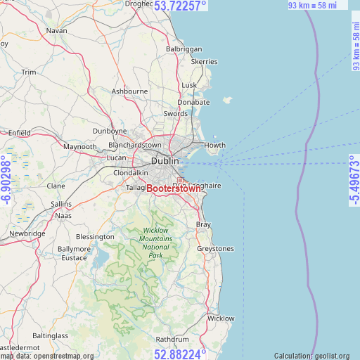
Booterstown GPS coordinates[2]
53° 18' 16.092" North, 6° 11' 59.46" West
| Map corner | latitude | longitude |
|---|---|---|
| Upper-left | 53.72257°, | -6.90298° |
| Center: | 53.30447°, | -6.19985° |
| Lower-right: | 52.88224°, | -5.49673° |
| Map W x H: | 93.4×93.4 km | = 58×58mi |
| max Lat: | 55.25° ⇑43.8% North |
| Booterstown: | 53.30447° |
| min Lat: | ⇓56.2% South 51.52487° |
| min Long | Booterstown | max Long |
| -10.26889° | -6.19985° | -6.04944° |
| W 91.5%⇐ | ⇒8.5% E |
Elevation
Elevation of Booterstown is 26 m = 85 ft, and this is 28.5 m = 94 ft below average elevation for this country.
| Max E: |
262 m = 860 ft | 70.4% |
| Avg. | 54.5 m = 179 ft | |
| Booterstown | 26 m = 85 ft | |
Min E: |
0 m = 0 ft | 29.6% |
See also: Ireland elevation on elevation.city.
Geographical zone
Booterstown is located in North temperate zone (between Tropic of Cancer and the Arctic Circle). Distance of this North polar circle is 1474.3 km =916.1 mi to North.| Distance of | km | miles | from Booterstown |
|---|---|---|---|
| North Pole | 4080.2 | 2535.3 | to North |
| Arctic Circle | 1474.3 | 916.1 | to North |
| Tropic Cancer | 3321 | 2063.6 | to South |
| Equator | 5926.9 | 3682.8 | to South |


Nearby cities:
15 places around Booterstown: (largest is in red/bold)
• Balally
4.1 km =2.5 mi,  216°
216°
• Blackrock
1.5 km =0.9 mi,  102°
102°
• Clonskeagh
2.4 km =1.5 mi,  298°
298°
• Donnybrook
1.8 km =1.1 mi, 304°
• Dublin
4.6 km =2.9 mi,  314°
314°
• Dundrum
4.1 km =2.5 mi,  248°
248°
• Dún Laoghaire
4.4 km =2.7 mi,  105°
105°
• Foxrock
4.5 km =2.8 mi,  157°
157°
• Milltown
3.2 km =2 mi,  287°
287°
• Monkstown
3.4 km =2.1 mi, 112°
• Mount Merrion
1.1 km =0.7 mi,  244°
244°
• Rathmines
4.6 km =2.9 mi, 292°
• Ringsend
4.5 km =2.8 mi,  337°
337°
• Sandyford
3.7 km =2.3 mi,  207°
207°
• Sandymount
3 km =1.9 mi,  330°
330°
Sources, notices
• [Note1] Compared only with cities in Ireland existing in our database
• [Src1] Map data: © OpenStreetMap contributors (CC-BY-SA)
• [Src2] Other city data from geonames.org with taken over terms of usage.
• [Src3] Geographical zone / Annual Mean Temperature by Robert A. Rohde @ Wikipedia
