Templeogue geodata
Templeogue (Leinster) is a section of populated place; located in Ireland in Europe/Dublin (GMT+1) time zone. With population of 7,023 people, there are 93 cities with bigger population in this country. Compared to other cities in Ireland, 55% of cities are located further ↓South; 82.7% of cities are located further ←West and 56.5% of cities have lower elevation than Templeogue. Note1


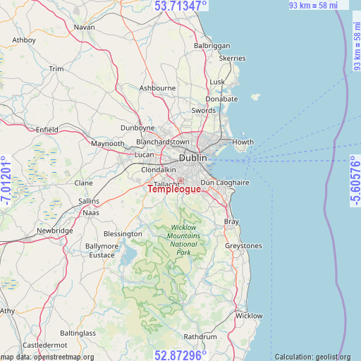
Templeogue GPS coordinates[2]
53° 17' 43.008" North, 6° 18' 32.004" West
| Map corner | latitude | longitude |
|---|---|---|
| Upper-left | 53.71347°, | -7.01201° |
| Center: | 53.29528°, | -6.30889° |
| Lower-right: | 52.87296°, | -5.60576° |
| Map W x H: | 93.5×93.5 km | = 58.1×58.1mi |
| max Lat: | 55.25° ⇑45% North |
| Templeogue: | 53.29528° |
| min Lat: | ⇓55% South 51.52487° |
| min Long | Templeogue | max Long |
| -10.26889° | -6.30889° | -6.04944° |
| W 82.7%⇐ | ⇒17.3% E |
Elevation
Elevation of Templeogue is 57 m = 187 ft, and this is 2.5 m = 8 ft above average elevation for this country.
| Max E: |
262 m = 860 ft | 43.5% |
| Templeogue | 57 m 187 ft | |
| Avg. | 54.5 m = 179 ft | |
Min E: |
0 m = 0 ft | 56.5% |
See also: Ireland elevation on elevation.city.
Geographical zone
Templeogue is located in North temperate zone (between Tropic of Cancer and the Arctic Circle). Distance of this North polar circle is 1475.3 km =916.7 mi to North.| Distance of | km | miles | from Templeogue |
|---|---|---|---|
| North Pole | 4081.2 | 2535.9 | to North |
| Arctic Circle | 1475.3 | 916.7 | to North |
| Tropic Cancer | 3320 | 2063 | to South |
| Equator | 5925.9 | 3682.2 | to South |


Nearby cities:
15 places around Templeogue: (largest is in red/bold)
• Balally
5.3 km =3.3 mi,  114°
114°
• Ballinteer
4.3 km =2.7 mi,  122°
122°
• Ballyboden
1.7 km =1.1 mi,  196°
196°
• Crumlin
2.9 km =1.8 mi,  352°
352°
• Dundrum
3.5 km =2.2 mi,  98°
98°
• Firhouse
2.5 km =1.6 mi,  233°
233°
• Greenhills
4.4 km =2.7 mi,  5°
5°
• Knocklyon
2.2 km =1.4 mi,  221°
221°
• Milltown
4.7 km =2.9 mi,  64°
64°
• Oldbawn
4.5 km =2.8 mi,  240°
240°
• Rathgar
3.1 km =1.9 mi,  46°
46°
• Rathmines
4.1 km =2.5 mi, 47°
• Rialto
4.6 km =2.9 mi, 9°
• Tallaght
4.4 km =2.7 mi,  256°
256°
• Terenure
2.2 km =1.4 mi,  44°
44°
Sources, notices
• [Note1] Compared only with cities in Ireland existing in our database
• [Src1] Map data: © OpenStreetMap contributors (CC-BY-SA)
• [Src2] Other city data from geonames.org with taken over terms of usage.
• [Src3] Geographical zone / Annual Mean Temperature by Robert A. Rohde @ Wikipedia
