Crumlin geodata
Crumlin (Leinster) is a populated place; located in Ireland in Europe/Dublin (GMT+0) time zone. With population of 11,294 people, there are 47 cities with bigger population in this country. Compared to other cities in Ireland, 57.7% of cities are located further ↓South; 82.5% of cities are located further ←West and 51.2% of cities have higher elevation than Crumlin. Note1


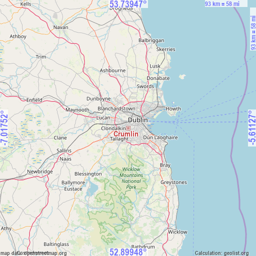
Crumlin GPS coordinates[2]
53° 19' 17.544" North, 6° 18' 51.804" West
| Map corner | latitude | longitude |
|---|---|---|
| Upper-left | 53.73947°, | -7.01752° |
| Center: | 53.32154°, | -6.31439° |
| Lower-right: | 52.89948°, | -5.61127° |
| Map W x H: | 93.4×93.4 km | = 58×58mi |
| max Lat: | 55.25° ⇑42.3% North |
| Crumlin: | 53.32154° |
| min Lat: | ⇓57.7% South 51.52487° |
| min Long | Crumlin | max Long |
| -10.26889° | -6.31439° | -6.04944° |
| W 82.5%⇐ | ⇒17.5% E |
Elevation
Elevation of Crumlin is 49 m = 161 ft, and this is 5.5 m = 18 ft below average elevation for this country.
| Max E: |
262 m = 860 ft | 51.2% |
| Avg. | 54.5 m = 179 ft | |
| Crumlin | 49 m = 161 ft | |
Min E: |
0 m = 0 ft | 48.8% |
See also: Ireland elevation on elevation.city.
Geographical zone
Crumlin is located in North temperate zone (between Tropic of Cancer and the Arctic Circle). Distance of this North polar circle is 1472.4 km =914.9 mi to North.| Distance of | km | miles | from Crumlin |
|---|---|---|---|
| North Pole | 4078.3 | 2534.1 | to North |
| Arctic Circle | 1472.4 | 914.9 | to North |
| Tropic Cancer | 3322.9 | 2064.8 | to South |
| Equator | 5928.8 | 3684 | to South |


Nearby cities:
15 places around Crumlin: (largest is in red/bold)
• Ballyboden
4.6 km =2.9 mi,  181°
181°
• Ballyfermot
3.6 km =2.2 mi,  311°
311°
• Chapelizod
3.5 km =2.2 mi,  327°
327°
• Cherry Orchard
4.5 km =2.8 mi,  290°
290°
• Dublin
4.5 km =2.8 mi,  73°
73°
• Dundrum
5.1 km =3.2 mi,  132°
132°
• Firhouse
4.7 km =2.9 mi,  200°
200°
• Greenhills
1.6 km =1 mi,  27°
27°
• Knocklyon
4.7 km =2.9 mi,  193°
193°
• Milltown
4.7 km =2.9 mi,  101°
101°
• Rathgar
2.7 km =1.7 mi,  106°
106°
• Rathmines
3.4 km =2.1 mi,  92°
92°
• Rialto
2 km =1.2 mi, 34°
• Templeogue
2.9 km =1.8 mi,  172°
172°
• Terenure
2.3 km =1.4 mi,  124°
124°
Sources, notices
• [Note1] Compared only with cities in Ireland existing in our database
• [Src1] Map data: © OpenStreetMap contributors (CC-BY-SA)
• [Src2] Other city data from geonames.org with taken over terms of usage.
• [Src3] Geographical zone / Annual Mean Temperature by Robert A. Rohde @ Wikipedia
