Ballyfermot geodata
Ballyfermot (Leinster) is a populated place; located in Ireland in Europe/Dublin (GMT+1) time zone. With population of 8,558 people, there are 73 cities with bigger population in this country. Compared to other cities in Ireland, 60.5% of cities are located further ↓South; 81.2% of cities are located further ←West and 80.5% of cities have higher elevation than Ballyfermot. Note1


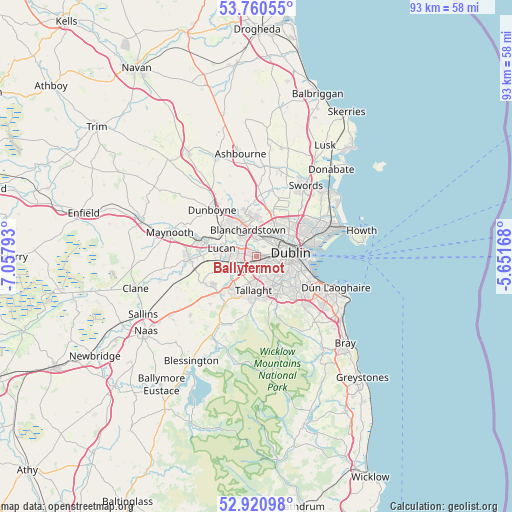
Ballyfermot GPS coordinates[2]
53° 20' 34.188" North, 6° 21' 17.28" West
| Map corner | latitude | longitude |
|---|---|---|
| Upper-left | 53.76055°, | -7.05793° |
| Center: | 53.34283°, | -6.3548° |
| Lower-right: | 52.92098°, | -5.65168° |
| Map W x H: | 93.4×93.3 km | = 58×58mi |
| max Lat: | 55.25° ⇑39.5% North |
| Ballyfermot: | 53.34283° |
| min Lat: | ⇓60.5% South 51.52487° |
| min Long | Ballyfermot | max Long |
| -10.26889° | -6.3548° | -6.04944° |
| W 81.2%⇐ | ⇒18.8% E |
Elevation
Elevation of Ballyfermot is 17 m = 56 ft, and this is 37.5 m = 123 ft below average elevation for this country.
| Max E: |
262 m = 860 ft | 80.5% |
| Avg. | 54.5 m = 179 ft | |
| Ballyfermot | 17 m = 56 ft | |
Min E: |
0 m = 0 ft | 19.5% |
See also: Ireland elevation on elevation.city.
Geographical zone
Ballyfermot is located in North temperate zone (between Tropic of Cancer and the Arctic Circle). Distance of this North polar circle is 1470 km =913.4 mi to North.| Distance of | km | miles | from Ballyfermot |
|---|---|---|---|
| North Pole | 4075.9 | 2532.6 | to North |
| Arctic Circle | 1470 | 913.4 | to North |
| Tropic Cancer | 3325.2 | 2066.2 | to South |
| Equator | 5931.2 | 3685.5 | to South |


Nearby cities:
15 places around Ballyfermot: (largest is in red/bold)
• Blanchardstown
5.2 km =3.2 mi,  344°
344°
• Cabra
4.8 km =3 mi,  56°
56°
• Castleknock
3.6 km =2.2 mi,  350°
350°
• Chapelizod
1 km =0.6 mi,  51°
51°
• Cherry Orchard
1.7 km =1.1 mi,  243°
243°
• Clondalkin
3.5 km =2.2 mi,  234°
234°
• Crumlin
3.6 km =2.2 mi,  131°
131°
• Finglas
6.4 km =4 mi,  36°
36°
• Glasnevin
6.3 km =3.9 mi, 51°
• Greenhills
3.6 km =2.2 mi,  104°
104°
• Palmerstown
1.7 km =1.1 mi,  298°
298°
• Rathgar
6.2 km =3.9 mi,  120°
120°
• Rialto
3.9 km =2.4 mi, 100°
• Templeogue
6.1 km =3.8 mi,  150°
150°
• Terenure
5.9 km =3.7 mi, 128°
Sources, notices
• [Note1] Compared only with cities in Ireland existing in our database
• [Src1] Map data: © OpenStreetMap contributors (CC-BY-SA)
• [Src2] Other city data from geonames.org with taken over terms of usage.
• [Src3] Geographical zone / Annual Mean Temperature by Robert A. Rohde @ Wikipedia
