Chapelizod geodata
Chapelizod (Leinster) is a populated place; located in Ireland in Europe/Dublin (GMT+1) time zone. With population of 5,296 people, there are 130 cities with bigger population in this country. Compared to other cities in Ireland, 60.7% of cities are located further ↓South; 81.6% of cities are located further ←West and 81.2% of cities have higher elevation than Chapelizod. Note1


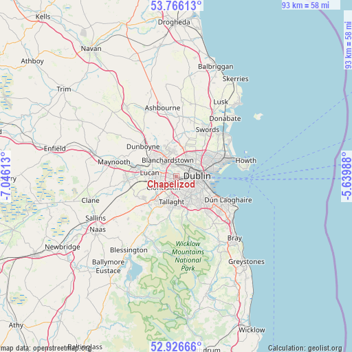
Chapelizod GPS coordinates[2]
53° 20' 54.456" North, 6° 20' 34.836" West
| Map corner | latitude | longitude |
|---|---|---|
| Upper-left | 53.76613°, | -7.04613° |
| Center: | 53.34846°, | -6.34301° |
| Lower-right: | 52.92666°, | -5.63988° |
| Map W x H: | 93.3×93.3 km | = 58×58mi |
| max Lat: | 55.25° ⇑39.3% North |
| Chapelizod: | 53.34846° |
| min Lat: | ⇓60.7% South 51.52487° |
| min Long | Chapelizod | max Long |
| -10.26889° | -6.34301° | -6.04944° |
| W 81.6%⇐ | ⇒18.4% E |
Elevation
Elevation of Chapelizod is 16 m = 52 ft, and this is 38.5 m = 126 ft below average elevation for this country.
| Max E: |
262 m = 860 ft | 81.2% |
| Avg. | 54.5 m = 179 ft | |
| Chapelizod | 16 m = 52 ft | |
Min E: |
0 m = 0 ft | 18.8% |
See also: Ireland elevation on elevation.city.
Geographical zone
Chapelizod is located in North temperate zone (between Tropic of Cancer and the Arctic Circle). Distance of this North polar circle is 1469.4 km =913 mi to North.| Distance of | km | miles | from Chapelizod |
|---|---|---|---|
| North Pole | 4075.3 | 2532.3 | to North |
| Arctic Circle | 1469.4 | 913 | to North |
| Tropic Cancer | 3325.9 | 2066.6 | to South |
| Equator | 5931.8 | 3685.8 | to South |


Nearby cities:
15 places around Chapelizod: (largest is in red/bold)
• Ballyfermot
1 km =0.6 mi,  231°
231°
• Blanchardstown
4.9 km =3 mi,  333°
333°
• Cabra
3.8 km =2.4 mi,  57°
57°
• Castleknock
3.2 km =2 mi,  335°
335°
• Cherry Orchard
2.7 km =1.7 mi,  239°
239°
• Clondalkin
4.5 km =2.8 mi, 233°
• Crumlin
3.5 km =2.2 mi,  147°
147°
• Finglas
5.5 km =3.4 mi,  34°
34°
• Glasnevin
5.3 km =3.3 mi,  51°
51°
• Greenhills
3.1 km =1.9 mi,  120°
120°
• Palmerstown
2.3 km =1.4 mi,  274°
274°
• Rathgar
5.9 km =3.7 mi,  129°
129°
• Rathmines
6.1 km =3.8 mi, 120°
• Rialto
3.3 km =2.1 mi,  114°
114°
• Terenure
5.8 km =3.6 mi,  138°
138°
Sources, notices
• [Note1] Compared only with cities in Ireland existing in our database
• [Src1] Map data: © OpenStreetMap contributors (CC-BY-SA)
• [Src2] Other city data from geonames.org with taken over terms of usage.
• [Src3] Geographical zone / Annual Mean Temperature by Robert A. Rohde @ Wikipedia
