Cahersiveen geodata
Cahersiveen (Munster) is a populated place; located in Ireland in Europe/Dublin (GMT+1) time zone. With population of 1,168 people, there are 317 cities with bigger population in this country. Compared to other cities in Ireland, 93.2% of cities are located further ↑North; 99.8% of cities are located further →East and 82.9% of cities have higher elevation than Cahersiveen. Note1


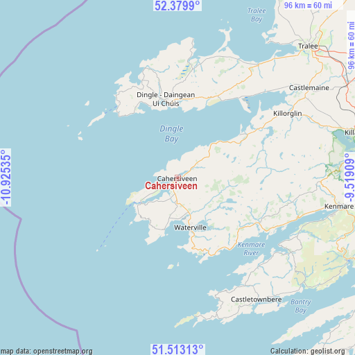
Cahersiveen GPS coordinates[2]
51° 56' 54.996" North, 10° 13' 19.992" West
| Map corner | latitude | longitude |
|---|---|---|
| Upper-left | 52.3799°, | -10.92535° |
| Center: | 51.94861°, | -10.22222° |
| Lower-right: | 51.51313°, | -9.51909° |
| Map W x H: | 96.4×96.4 km | = 59.9×59.9mi |
| max Lat: | 55.25° ⇑93.2% North |
| Cahersiveen: | 51.94861° |
| min Lat: | ⇓6.8% South 51.52487° |
| min Long | Cahersiveen | max Long |
| -10.26889° | -10.22222° | -6.04944° |
| W 0.2%⇐ | ⇒99.8% E |
Elevation
Elevation of Cahersiveen is 15 m = 49 ft, and this is 39.5 m = 130 ft below average elevation for this country.
| Max E: |
262 m = 860 ft | 82.9% |
| Avg. | 54.5 m = 179 ft | |
| Cahersiveen | 15 m = 49 ft | |
Min E: |
0 m = 0 ft | 17.1% |
See also: Ireland elevation on elevation.city.
Geographical zone
Cahersiveen is located in North temperate zone (between Tropic of Cancer and the Arctic Circle). Distance of this North polar circle is 1625 km =1009.7 mi to North.| Distance of | km | miles | from Cahersiveen |
|---|---|---|---|
| North Pole | 4230.9 | 2629 | to North |
| Arctic Circle | 1625 | 1009.7 | to North |
| Tropic Cancer | 3170.2 | 1969.9 | to South |
| Equator | 5776.1 | 3589.1 | to South |


Nearby cities:
15 places around Cahersiveen: (largest is in red/bold)
• Ardfert
51.5 km =32 mi,  36°
36°
• Baile an Mhuilinn
41.2 km =25.6 mi,  57°
57°
• Ballyheige
55.1 km =34.2 mi,  28°
28°
• Bantry
60.7 km =37.7 mi,  119°
119°
• Castleisland
60.6 km =37.7 mi, 58°
• Castletownbere
39.4 km =24.5 mi,  147°
147°
• Cill Airne
50.4 km =31.3 mi,  75°
75°
• Dingle
21.6 km =13.4 mi,  351°
351°
• Fenit
44.2 km =27.5 mi, 33°
• Kenmare
44.4 km =27.6 mi,  99°
99°
• Killorglin
34.4 km =21.4 mi, 60°
• Lixnaw
65.5 km =40.7 mi, 39°
• Scarriff
10.7 km =6.6 mi,  159°
159°
• Schull
66.1 km =41.1 mi,  135°
135°
• Tralee
50.4 km =31.3 mi, 44°
Sources, notices
• [Note1] Compared only with cities in Ireland existing in our database
• [Src1] Map data: © OpenStreetMap contributors (CC-BY-SA)
• [Src2] Other city data from geonames.org with taken over terms of usage.
• [Src3] Geographical zone / Annual Mean Temperature by Robert A. Rohde @ Wikipedia
