Castleisland geodata
Castleisland (Munster) is a populated place; located in Ireland in Europe/Dublin (GMT+1) time zone. With population of 2,513 people, there are 205 cities with bigger population in this country. Compared to other cities in Ireland, 87.9% of cities are located further ↑North; 95.3% of cities are located further →East and 66% of cities have higher elevation than Castleisland. Note1


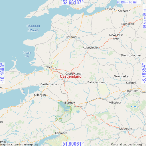
Castleisland GPS coordinates[2]
52° 13' 59.988" North, 9° 28' 0.012" West
| Map corner | latitude | longitude |
|---|---|---|
| Upper-left | 52.66187°, | -10.1698° |
| Center: | 52.23333°, | -9.46667° |
| Lower-right: | 51.80061°, | -8.76354° |
| Map W x H: | 95.8×95.8 km | = 59.5×59.5mi |
| max Lat: | 55.25° ⇑87.9% North |
| Castleisland: | 52.23333° |
| min Lat: | ⇓12.1% South 51.52487° |
| min Long | Castleisland | max Long |
| -10.26889° | -9.46667° | -6.04944° |
| W 4.7%⇐ | ⇒95.3% E |
Elevation
Elevation of Castleisland is 29 m = 95 ft, and this is 25.5 m = 84 ft below average elevation for this country.
| Max E: |
262 m = 860 ft | 66% |
| Avg. | 54.5 m = 179 ft | |
| Castleisland | 29 m = 95 ft | |
Min E: |
0 m = 0 ft | 34% |
See also: Ireland elevation on elevation.city.
Geographical zone
Castleisland is located in North temperate zone (between Tropic of Cancer and the Arctic Circle). Distance of this North polar circle is 1593.4 km =990.1 mi to North.| Distance of | km | miles | from Castleisland |
|---|---|---|---|
| North Pole | 4199.3 | 2609.3 | to North |
| Arctic Circle | 1593.4 | 990.1 | to North |
| Tropic Cancer | 3201.9 | 1989.6 | to South |
| Equator | 5807.8 | 3608.8 | to South |


Nearby cities:
15 places around Castleisland: (largest is in red/bold)
• Abbeyfeale
19.9 km =12.4 mi,  34°
34°
• Ardfert
23.4 km =14.5 mi,  295°
295°
• Baile an Mhuilinn
19.4 km =12.1 mi,  241°
241°
• Ballybunnion
33.9 km =21.1 mi,  335°
335°
• Ballyduff
27.7 km =17.2 mi,  331°
331°
• Ballyheige
30 km =18.6 mi, 303°
• Cill Airne
19.5 km =12.1 mi,  188°
188°
• Fenit
27.8 km =17.3 mi,  280°
280°
• Killorglin
26.2 km =16.3 mi, 235°
• Listowel
23.7 km =14.7 mi,  356°
356°
• Lixnaw
21.7 km =13.5 mi, 331°
• Millstreet
33.8 km =21 mi,  124°
124°
• Newmarket
31.8 km =19.8 mi,  93°
93°
• Rathmore
23.9 km =14.9 mi,  134°
134°
• Tralee
16.6 km =10.3 mi, 284°
Sources, notices
• [Note1] Compared only with cities in Ireland existing in our database
• [Src1] Map data: © OpenStreetMap contributors (CC-BY-SA)
• [Src2] Other city data from geonames.org with taken over terms of usage.
• [Src3] Geographical zone / Annual Mean Temperature by Robert A. Rohde @ Wikipedia
