Schull geodata
Schull (Munster) is a populated place; located in Ireland in Europe/Dublin (GMT+1) time zone. With population of 658 people, there are 452 cities with bigger population in this country. Compared to other cities in Ireland, 100% of cities are located further ↑North; 96.4% of cities are located further →East and 67.4% of cities have higher elevation than Schull. Note1


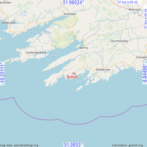
Schull GPS coordinates[2]
51° 31' 29.532" North, 9° 32' 52.728" West
| Map corner | latitude | longitude |
|---|---|---|
| Upper-left | 51.96024°, | -10.25111° |
| Center: | 51.52487°, | -9.54798° |
| Lower-right: | 51.0853°, | -8.84486° |
| Map W x H: | 97.3×97.3 km | = 60.5×60.5mi |
| max Lat: | 55.25° ⇑100% North |
| Schull: | 51.52487° |
| min Lat: | ⇓0% South 51.52487° |
| min Long | Schull | max Long |
| -10.26889° | -9.54798° | -6.04944° |
| W 3.6%⇐ | ⇒96.4% E |
Elevation
Elevation of Schull is 28 m = 92 ft, and this is 26.5 m = 87 ft below average elevation for this country.
| Max E: |
262 m = 860 ft | 67.4% |
| Avg. | 54.5 m = 179 ft | |
| Schull | 28 m = 92 ft | |
Min E: |
0 m = 0 ft | 32.6% |
See also: Ireland elevation on elevation.city.
Geographical zone
Schull is located in North temperate zone (between Tropic of Cancer and the Arctic Circle). Distance of this North polar circle is 1672.1 km =1039 mi to North.| Distance of | km | miles | from Schull |
|---|---|---|---|
| North Pole | 4278 | 2658.2 | to North |
| Arctic Circle | 1672.1 | 1039 | to North |
| Tropic Cancer | 3123.1 | 1940.6 | to South |
| Equator | 5729 | 3559.8 | to South |


Nearby cities:
15 places around Schull: (largest is in red/bold)
• Bandon
60.8 km =37.8 mi,  66°
66°
• Bantry
18.9 km =11.7 mi,  21°
21°
• Castletownbere
28.9 km =18 mi,  298°
298°
• Cill Airne
59.5 km =37 mi,  2°
2°
• Clonakilty
48.1 km =29.9 mi,  76°
76°
• Courtmacsherry
59.5 km =37 mi, 78°
• Derry
35.1 km =21.8 mi, 78°
• Dunmanway
36.6 km =22.7 mi,  54°
54°
• Enniskeane
48.7 km =30.3 mi,  60°
60°
• Kenmare
39.9 km =24.8 mi,  356°
356°
• Killorglin
66 km =41 mi,  345°
345°
• Macroom
58.2 km =36.2 mi,  43°
43°
• Ross Carbery
36.1 km =22.4 mi, 80°
• Scarriff
56.6 km =35.2 mi,  310°
310°
• Skibbereen
19.7 km =12.2 mi, 81°
Sources, notices
• [Note1] Compared only with cities in Ireland existing in our database
• [Src1] Map data: © OpenStreetMap contributors (CC-BY-SA)
• [Src2] Other city data from geonames.org with taken over terms of usage.
• [Src3] Geographical zone / Annual Mean Temperature by Robert A. Rohde @ Wikipedia
