Tralee geodata
Tralee (Munster) is a seat of a second-order administrative division; located in Ireland in Europe/Dublin (GMT+1) time zone. With population of 22,941 people, there are 13 cities with bigger population in this country. Compared to other cities in Ireland, 86.5% of cities are located further ↑North; 97.5% of cities are located further →East and 92.6% of cities have higher elevation than Tralee. Note1


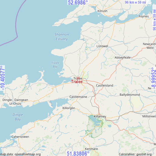
Tralee GPS coordinates[2]
52° 16' 13.512" North, 9° 42' 9.504" West
| Map corner | latitude | longitude |
|---|---|---|
| Upper-left | 52.6986°, | -10.40577° |
| Center: | 52.27042°, | -9.70264° |
| Lower-right: | 51.83806°, | -8.99952° |
| Map W x H: | 95.7×95.7 km | = 59.5×59.5mi |
| max Lat: | 55.25° ⇑86.5% North |
| Tralee: | 52.27042° |
| min Lat: | ⇓13.5% South 51.52487° |
| min Long | Tralee | max Long |
| -10.26889° | -9.70264° | -6.04944° |
| W 2.5%⇐ | ⇒97.5% E |
Elevation
Elevation of Tralee is 8 m = 26 ft, and this is 46.5 m = 153 ft below average elevation for this country.
| Max E: |
262 m = 860 ft | 92.6% |
| Avg. | 54.5 m = 179 ft | |
| Tralee | 8 m = 26 ft | |
Min E: |
0 m = 0 ft | 7.4% |
See also: Ireland elevation on elevation.city.
Geographical zone
Tralee is located in North temperate zone (between Tropic of Cancer and the Arctic Circle). Distance of this North polar circle is 1589.2 km =987.5 mi to North.| Distance of | km | miles | from Tralee |
|---|---|---|---|
| North Pole | 4195.1 | 2606.7 | to North |
| Arctic Circle | 1589.2 | 987.5 | to North |
| Tropic Cancer | 3206 | 1992.1 | to South |
| Equator | 5811.9 | 3611.3 | to South |


Nearby cities:
15 places around Tralee: (largest is in red/bold)
• Abbeyfeale
29.9 km =18.6 mi,  65°
65°
• Ardfert
7.7 km =4.8 mi,  318°
318°
• Baile an Mhuilinn
13.4 km =8.3 mi,  184°
184°
• Ballybunnion
26.8 km =16.7 mi,  4°
4°
• Ballyduff
20.3 km =12.6 mi,  7°
7°
• Ballyheige
15.4 km =9.6 mi, 324°
• Castleisland
16.6 km =10.3 mi,  104°
104°
• Cill Airne
26.9 km =16.7 mi,  150°
150°
• Dingle
41.2 km =25.6 mi,  249°
249°
• Fenit
11.3 km =7 mi,  275°
275°
• Killorglin
19.7 km =12.2 mi,  196°
196°
• Listowel
24.5 km =15.2 mi,  37°
37°
• Lixnaw
16.1 km =10 mi,  21°
21°
• Rathmore
39.1 km =24.3 mi,  122°
122°
• Tarbert
40.3 km =25 mi,  33°
33°
Sources, notices
• [Note1] Compared only with cities in Ireland existing in our database
• [Src1] Map data: © OpenStreetMap contributors (CC-BY-SA)
• [Src2] Other city data from geonames.org with taken over terms of usage.
• [Src3] Geographical zone / Annual Mean Temperature by Robert A. Rohde @ Wikipedia
