Balbriggan geodata
Balbriggan (Leinster) is a populated place; located in Ireland in Europe/Dublin (GMT+1) time zone. With population of 23,364 people, there are 12 cities with bigger population in this country. Compared to other cities in Ireland, 75.3% of cities are located further ↓South; 92.4% of cities are located further ←West and 95.4% of cities have higher elevation than Balbriggan. Note1


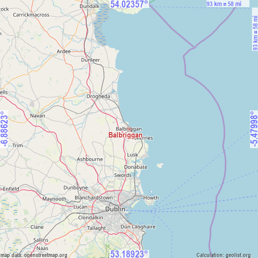
Balbriggan GPS coordinates[2]
53° 36' 30.456" North, 6° 10' 59.16" West
| Map corner | latitude | longitude |
|---|---|---|
| Upper-left | 54.02357°, | -6.88623° |
| Center: | 53.60846°, | -6.1831° |
| Lower-right: | 53.18923°, | -5.47998° |
| Map W x H: | 92.8×92.8 km | = 57.7×57.7mi |
| max Lat: | 55.25° ⇑24.7% North |
| Balbriggan: | 53.60846° |
| min Lat: | ⇓75.3% South 51.52487° |
| min Long | Balbriggan | max Long |
| -10.26889° | -6.1831° | -6.04944° |
| W 92.4%⇐ | ⇒7.6% E |
Elevation
Elevation of Balbriggan is 6 m = 20 ft, and this is 48.5 m = 159 ft below average elevation for this country.
| Max E: |
262 m = 860 ft | 95.4% |
| Avg. | 54.5 m = 179 ft | |
| Balbriggan | 6 m = 20 ft | |
Min E: |
0 m = 0 ft | 4.6% |
See also: Ireland elevation on elevation.city.
Geographical zone
Balbriggan is located in North temperate zone (between Tropic of Cancer and the Arctic Circle). Distance of this North polar circle is 1440.5 km =895.1 mi to North.| Distance of | km | miles | from Balbriggan |
|---|---|---|---|
| North Pole | 4046.4 | 2514.3 | to North |
| Arctic Circle | 1440.5 | 895.1 | to North |
| Tropic Cancer | 3354.8 | 2084.6 | to South |
| Equator | 5960.7 | 3703.8 | to South |


Nearby cities:
15 places around Balbriggan: (largest is in red/bold)
• An Ros
10.7 km =6.6 mi,  151°
151°
• Ashbourne
17.8 km =11.1 mi,  232°
232°
• Balrothery
2.3 km =1.4 mi,  187°
187°
• Donabate
13.6 km =8.5 mi,  171°
171°
• Drogheda
16.4 km =10.2 mi,  318°
318°
• Duleek
16.5 km =10.3 mi,  289°
289°
• Julianstown
9.8 km =6.1 mi, 316°
• Laytown
9 km =5.6 mi,  335°
335°
• Loughshinny
9.3 km =5.8 mi,  134°
134°
• Lusk
9.1 km =5.7 mi, 172°
• Malahide
17.6 km =10.9 mi, 173°
• Portraine
13.3 km =8.3 mi,  159°
159°
• Skerries
5.7 km =3.5 mi,  120°
120°
• Stamullin
6.1 km =3.8 mi, 292°
• Swords
16.7 km =10.4 mi, 187°
Sources, notices
• [Note1] Compared only with cities in Ireland existing in our database
• [Src1] Map data: © OpenStreetMap contributors (CC-BY-SA)
• [Src2] Other city data from geonames.org with taken over terms of usage.
• [Src3] Geographical zone / Annual Mean Temperature by Robert A. Rohde @ Wikipedia
