Laytown geodata
Laytown (Leinster) is a populated place; located in Ireland in Europe/Dublin (GMT+1) time zone. With population of 10,889 people, there are 50 cities with bigger population in this country. Compared to other cities in Ireland, 78% of cities are located further ↓South; 87.3% of cities are located further ←West and 93.9% of cities have higher elevation than Laytown. Note1


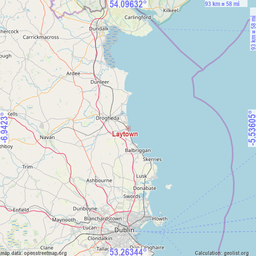
Laytown GPS coordinates[2]
53° 40' 54.984" North, 6° 14' 21.012" West
| Map corner | latitude | longitude |
|---|---|---|
| Upper-left | 54.09632°, | -6.9423° |
| Center: | 53.68194°, | -6.23917° |
| Lower-right: | 53.26344°, | -5.53605° |
| Map W x H: | 92.6×92.6 km | = 57.5×57.5mi |
| max Lat: | 55.25° ⇑22% North |
| Laytown: | 53.68194° |
| min Lat: | ⇓78% South 51.52487° |
| min Long | Laytown | max Long |
| -10.26889° | -6.23917° | -6.04944° |
| W 87.3%⇐ | ⇒12.7% E |
Elevation
Elevation of Laytown is 7 m = 23 ft, and this is 47.5 m = 156 ft below average elevation for this country.
| Max E: |
262 m = 860 ft | 93.9% |
| Avg. | 54.5 m = 179 ft | |
| Laytown | 7 m = 23 ft | |
Min E: |
0 m = 0 ft | 6.1% |
See also: Ireland elevation on elevation.city.
Geographical zone
Laytown is located in North temperate zone (between Tropic of Cancer and the Arctic Circle). Distance of this North polar circle is 1432.3 km =890 mi to North.| Distance of | km | miles | from Laytown |
|---|---|---|---|
| North Pole | 4038.2 | 2509.2 | to North |
| Arctic Circle | 1432.3 | 890 | to North |
| Tropic Cancer | 3363 | 2089.7 | to South |
| Equator | 5968.9 | 3708.9 | to South |


Nearby cities:
15 places around Laytown: (largest is in red/bold)
• An Ros
19.6 km =12.2 mi,  153°
153°
• Balbriggan
9 km =5.6 mi,  155°
155°
• Balrothery
11 km =6.8 mi, 161°
• Clogherhead
12.4 km =7.7 mi,  0°
0°
• Collon
19.7 km =12.2 mi,  304°
304°
• Donore
12 km =7.5 mi,  275°
275°
• Drogheda
8.2 km =5.1 mi, 299°
• Duleek
12.2 km =7.6 mi,  256°
256°
• Julianstown
3.2 km =2 mi,  251°
251°
• Loughshinny
18 km =11.2 mi, 145°
• Lusk
17.9 km =11.1 mi, 163°
• Skerries
14 km =8.7 mi,  141°
141°
• Stamullin
6.2 km =3.9 mi,  198°
198°
• Termonfeckin
9.2 km =5.7 mi,  348°
348°
• Tullyallen
13.5 km =8.4 mi, 296°
Sources, notices
• [Note1] Compared only with cities in Ireland existing in our database
• [Src1] Map data: © OpenStreetMap contributors (CC-BY-SA)
• [Src2] Other city data from geonames.org with taken over terms of usage.
• [Src3] Geographical zone / Annual Mean Temperature by Robert A. Rohde @ Wikipedia
