Drogheda geodata
Drogheda (Leinster) is a populated place; located in Ireland in Europe/Dublin (GMT+1) time zone. With population of 33,441 people, there are 8 cities with bigger population in this country. Compared to other cities in Ireland, 78.9% of cities are located further ↓South; 81.4% of cities are located further ←West and 67.4% of cities have higher elevation than Drogheda. Note1


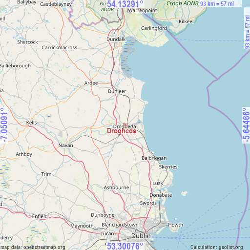
Drogheda GPS coordinates[2]
53° 43' 8.004" North, 6° 20' 52.008" West
| Map corner | latitude | longitude |
|---|---|---|
| Upper-left | 54.13291°, | -7.05091° |
| Center: | 53.71889°, | -6.34778° |
| Lower-right: | 53.30076°, | -5.64466° |
| Map W x H: | 92.5×92.5 km | = 57.5×57.5mi |
| max Lat: | 55.25° ⇑21.1% North |
| Drogheda: | 53.71889° |
| min Lat: | ⇓78.9% South 51.52487° |
| min Long | Drogheda | max Long |
| -10.26889° | -6.34778° | -6.04944° |
| W 81.4%⇐ | ⇒18.6% E |
Elevation
Elevation of Drogheda is 28 m = 92 ft, and this is 26.5 m = 87 ft below average elevation for this country.
| Max E: |
262 m = 860 ft | 67.4% |
| Avg. | 54.5 m = 179 ft | |
| Drogheda | 28 m = 92 ft | |
Min E: |
0 m = 0 ft | 32.6% |
See also: Ireland elevation on elevation.city.
Geographical zone
Drogheda is located in North temperate zone (between Tropic of Cancer and the Arctic Circle). Distance of this North polar circle is 1428.2 km =887.4 mi to North.| Distance of | km | miles | from Drogheda |
|---|---|---|---|
| North Pole | 4034.1 | 2506.7 | to North |
| Arctic Circle | 1428.2 | 887.4 | to North |
| Tropic Cancer | 3367.1 | 2092.2 | to South |
| Equator | 5973 | 3711.4 | to South |


Nearby cities:
15 places around Drogheda: (largest is in red/bold)
• Ardee
20.1 km =12.5 mi,  321°
321°
• Balbriggan
16.4 km =10.2 mi,  138°
138°
• Balrothery
18 km =11.2 mi, 143°
• Clogherhead
11 km =6.8 mi,  41°
41°
• Collon
11.5 km =7.1 mi,  307°
307°
• Donore
5.5 km =3.4 mi,  238°
238°
• Duleek
8.4 km =5.2 mi,  214°
214°
• Dunleer
13.3 km =8.3 mi,  346°
346°
• Julianstown
6.6 km =4.1 mi, 141°
• Kentstown
15.6 km =9.7 mi,  229°
229°
• Laytown
8.2 km =5.1 mi,  119°
119°
• Slane
12.9 km =8 mi,  265°
265°
• Stamullin
11.3 km =7 mi,  152°
152°
• Termonfeckin
7.2 km =4.5 mi,  46°
46°
• Tullyallen
5.3 km =3.3 mi,  291°
291°
Sources, notices
• [Note1] Compared only with cities in Ireland existing in our database
• [Src1] Map data: © OpenStreetMap contributors (CC-BY-SA)
• [Src2] Other city data from geonames.org with taken over terms of usage.
• [Src3] Geographical zone / Annual Mean Temperature by Robert A. Rohde @ Wikipedia
