Oldbawn geodata
Oldbawn (Leinster) is a populated place; located in Ireland in Europe/Dublin (GMT+0) time zone. With population of 9,784 people, there are 58 cities with bigger population in this country. Compared to other cities in Ireland, 51.8% of cities are located further ↓South; 80.3% of cities are located further ←West and 89.9% of cities have lower elevation than Oldbawn. Note1


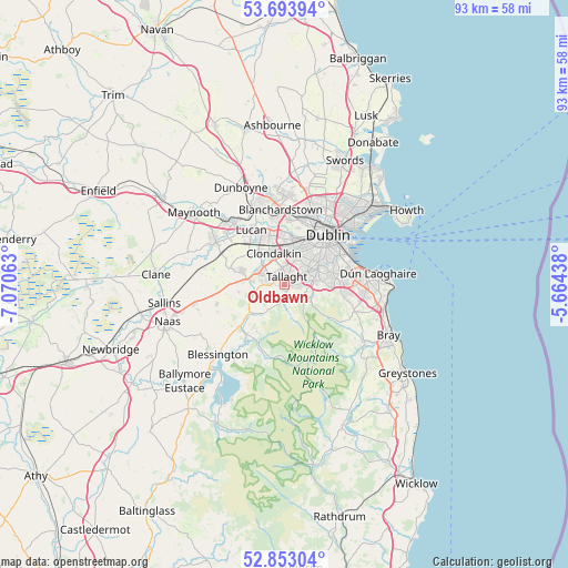
Oldbawn GPS coordinates[2]
53° 16' 32.016" North, 6° 22' 3" West
| Map corner | latitude | longitude |
|---|---|---|
| Upper-left | 53.69394°, | -7.07063° |
| Center: | 53.27556°, | -6.3675° |
| Lower-right: | 52.85304°, | -5.66438° |
| Map W x H: | 93.5×93.5 km | = 58.1×58.1mi |
| max Lat: | 55.25° ⇑48.2% North |
| Oldbawn: | 53.27556° |
| min Lat: | ⇓51.8% South 51.52487° |
| min Long | Oldbawn | max Long |
| -10.26889° | -6.3675° | -6.04944° |
| W 80.3%⇐ | ⇒19.7% E |
Elevation
Elevation of Oldbawn is 104 m = 341 ft, and this is 49.5 m = 162 ft above average elevation for this country.
| Max E: |
262 m = 860 ft | 10.1% |
| Oldbawn | 104 m 341 ft | |
| Avg. | 54.5 m = 179 ft | |
Min E: |
0 m = 0 ft | 89.9% |
See also: Ireland elevation on elevation.city.
Geographical zone
Oldbawn is located in North temperate zone (between Tropic of Cancer and the Arctic Circle). Distance of this North polar circle is 1477.5 km =918.1 mi to North.| Distance of | km | miles | from Oldbawn |
|---|---|---|---|
| North Pole | 4083.4 | 2537.3 | to North |
| Arctic Circle | 1477.5 | 918.1 | to North |
| Tropic Cancer | 3317.8 | 2061.6 | to South |
| Equator | 5923.7 | 3680.8 | to South |


Nearby cities:
15 places around Oldbawn: (largest is in red/bold)
• Ballyboden
3.4 km =2.1 mi,  80°
80°
• Ballyfermot
7.5 km =4.7 mi,  6°
6°
• Cherry Orchard
6.8 km =4.2 mi,  354°
354°
• Clondalkin
5.8 km =3.6 mi,  340°
340°
• Crumlin
6.2 km =3.9 mi,  34°
34°
• Dundrum
7.5 km =4.7 mi, 77°
• Firhouse
2 km =1.2 mi,  70°
70°
• Jobstown
2.7 km =1.7 mi,  277°
277°
• Knocklyon
2.5 km =1.6 mi, 77°
• Rathcoole
7 km =4.3 mi, 276°
• Rathgar
7.5 km =4.7 mi,  54°
54°
• Saggart
5.1 km =3.2 mi, 275°
• Tallaght
1.2 km =0.7 mi, 341°
• Templeogue
4.5 km =2.8 mi,  60°
60°
• Terenure
6.7 km =4.2 mi, 55°
Sources, notices
• [Note1] Compared only with cities in Ireland existing in our database
• [Src1] Map data: © OpenStreetMap contributors (CC-BY-SA)
• [Src2] Other city data from geonames.org with taken over terms of usage.
• [Src3] Geographical zone / Annual Mean Temperature by Robert A. Rohde @ Wikipedia
