Tallaght geodata
Tallaght (Leinster) is a seat of a second-order administrative division; located in Ireland in Europe/Dublin (GMT+1) time zone. With population of 64,282 people, there are 5 cities with bigger population in this country. Compared to other cities in Ireland, 53.7% of cities are located further ↓South; 80.1% of cities are located further ←West and 89.4% of cities have lower elevation than Tallaght. Note1


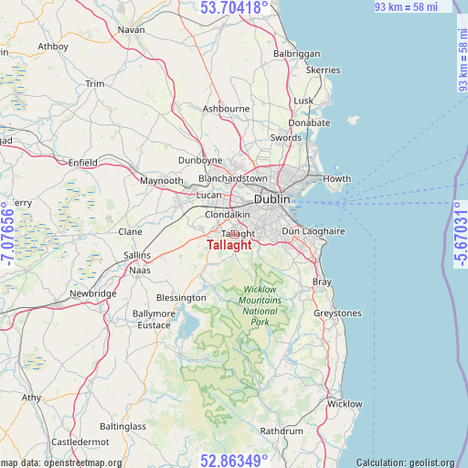
Tallaght GPS coordinates[2]
53° 17' 9.24" North, 6° 22' 24.384" West
| Map corner | latitude | longitude |
|---|---|---|
| Upper-left | 53.70418°, | -7.07656° |
| Center: | 53.2859°, | -6.37344° |
| Lower-right: | 52.86349°, | -5.67031° |
| Map W x H: | 93.5×93.5 km | = 58.1×58.1mi |
| max Lat: | 55.25° ⇑46.3% North |
| Tallaght: | 53.2859° |
| min Lat: | ⇓53.7% South 51.52487° |
| min Long | Tallaght | max Long |
| -10.26889° | -6.37344° | -6.04944° |
| W 80.1%⇐ | ⇒19.9% E |
Elevation
Elevation of Tallaght is 103 m = 338 ft, and this is 48.5 m = 159 ft above average elevation for this country.
| Max E: |
262 m = 860 ft | 10.6% |
| Tallaght | 103 m 338 ft | |
| Avg. | 54.5 m = 179 ft | |
Min E: |
0 m = 0 ft | 89.4% |
See also: Tallaght elevation on elevation.city.
Geographical zone
Tallaght is located in North temperate zone (between Tropic of Cancer and the Arctic Circle). Distance of this North polar circle is 1476.3 km =917.3 mi to North.| Distance of | km | miles | from Tallaght |
|---|---|---|---|
| North Pole | 4082.2 | 2536.6 | to North |
| Arctic Circle | 1476.3 | 917.3 | to North |
| Tropic Cancer | 3318.9 | 2062.3 | to South |
| Equator | 5924.8 | 3681.5 | to South |


Nearby cities:
15 places around Tallaght: (largest is in red/bold)
• Ballyboden
3.8 km =2.4 mi,  98°
98°
• Ballyfermot
6.4 km =4 mi,  11°
11°
• Chapelizod
7.2 km =4.5 mi,  16°
16°
• Cherry Orchard
5.6 km =3.5 mi,  356°
356°
• Clondalkin
4.6 km =2.9 mi,  339°
339°
• Crumlin
5.6 km =3.5 mi,  44°
44°
• Firhouse
2.3 km =1.4 mi, 101°
• Greenhills
7.2 km =4.5 mi, 40°
• Jobstown
2.4 km =1.5 mi,  250°
250°
• Knocklyon
2.9 km =1.8 mi, 102°
• Oldbawn
1.2 km =0.7 mi,  161°
161°
• Rathcoole
6.6 km =4.1 mi,  266°
266°
• Saggart
4.8 km =3 mi,  262°
262°
• Templeogue
4.4 km =2.7 mi,  76°
76°
• Terenure
6.4 km =4 mi,  65°
65°
Sources, notices
• [Note1] Compared only with cities in Ireland existing in our database
• [Src1] Map data: © OpenStreetMap contributors (CC-BY-SA)
• [Src2] Other city data from geonames.org with taken over terms of usage.
• [Src3] Geographical zone / Annual Mean Temperature by Robert A. Rohde @ Wikipedia
