Kiryat Netafim geodata
Kiryat Netafim is a populated place; located in Israel in Asia/Jerusalem (GMT+3) time zone. With population of 690 people, there are 163 cities with bigger population in this country. Compared to other cities in Israel, 57.4% of cities are located further ↑North; 55.6% of cities are located further ←West and 80.5% of cities have lower elevation than Kiryat Netafim. Note1


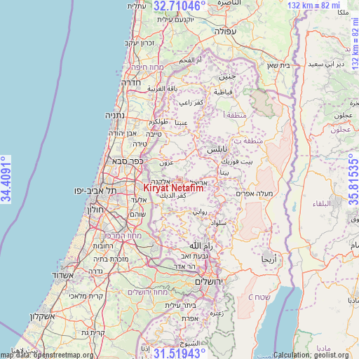
Kiryat Netafim GPS coordinates[2]
32° 7' 0.804" North, 35° 6' 43.992" East
| Map corner | latitude | longitude |
|---|---|---|
| Upper-left | 32.71046°, | 34.4091° |
| Center: | 32.11689°, | 35.11222° |
| Lower-right: | 31.51943°, | 35.81535° |
| Map W x H: | 132.4×132.4 km | = 82.3×82.3mi |
| max Lat: | 33.27918° ⇑57.4% North |
| Kiryat Netafim: | 32.11689° |
| min Lat: | ⇓42.6% South 29.55805° |
| min Long | Kiryat Netafim | max Long |
| 34.57149° | 35.11222° | 35.81084° |
| W 55.6%⇐ | ⇒44.4% E |
Elevation
Elevation of Kiryat Netafim is 442 m = 1450 ft, and this is 218.6 m = 717 ft above average elevation for this country.
| Max E: |
988 m = 3241 ft | 19.5% |
| Kiryat Netafim | 442 m 1450 ft | |
| Avg. | 223.4 m = 733 ft | |
Min E: |
-380 m = -1247 ft | 80.5% |
See also: Israel elevation on elevation.city.
Geographical zone
Kiryat Netafim is located in North temperate zone (between Tropic of Cancer and the Arctic Circle). Distance of this Northern Tropic circle is 965.1 km =599.7 mi to South.| Distance of | km | miles | from Kiryat Netafim |
|---|---|---|---|
| North Pole | 6436 | 3999.1 | to North |
| Arctic Circle | 3830.1 | 2379.9 | to North |
| Tropic Cancer | 965.1 | 599.7 | to South |
| Equator | 3571.1 | 2219 | to South |


Nearby cities:
15 places around Kiryat Netafim: (largest is in red/bold)
• Ariel
6.9 km =4.3 mi,  99°
99°
• Eṭ Ṭaiyiba
19.2 km =11.9 mi,  329°
329°
• Hod HaSharon
21.2 km =13.2 mi,  282°
282°
• Jaljūlya
15.5 km =9.6 mi,  285°
285°
• Kafr Qāsim
12.8 km =8 mi,  268°
268°
• Kfar Saba
20.4 km =12.7 mi, 288°
• Na'ale
17.7 km =11 mi,  194°
194°
• Neẖalim
20 km =12.4 mi,  251°
251°
• Nili
18 km =11.2 mi,  199°
199°
• Nirit
12.3 km =7.6 mi, 285°
• Revava
1.6 km =1 mi,  80°
80°
• Rosh Ha‘Ayin
14.8 km =9.2 mi,  260°
260°
• Shoham
20.5 km =12.7 mi,  230°
230°
• Talmon
19.9 km =12.4 mi,  173°
173°
• Tirah
20.1 km =12.5 mi,  310°
310°
Sources, notices
• [Note1] Compared only with cities in Israel existing in our database
• [Src1] Map data: © OpenStreetMap contributors (CC-BY-SA)
• [Src2] Other city data from geonames.org with taken over terms of usage.
• [Src3] Geographical zone / Annual Mean Temperature by Robert A. Rohde @ Wikipedia
