Tirah geodata
Tirah (Central District) is a populated place; located in Israel in Asia/Jerusalem (GMT+3) time zone. With population of 20,786 people, there are 64 cities with bigger population in this country. Compared to other cities in Israel, 50.9% of cities are located further ↑North; 63.9% of cities are located further →East and 58% of cities have higher elevation than Tirah. Note1


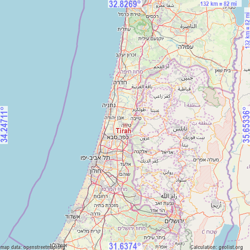
Tirah GPS coordinates[2]
32° 14' 2.76" North, 34° 57' 0.828" East
| Map corner | latitude | longitude |
|---|---|---|
| Upper-left | 32.8269°, | 34.24711° |
| Center: | 32.2341°, | 34.95023° |
| Lower-right: | 31.6374°, | 35.65336° |
| Map W x H: | 132.3×132.3 km | = 82.2×82.2mi |
| max Lat: | 33.27918° ⇑50.9% North |
| Tirah: | 32.2341° |
| min Lat: | ⇓49.1% South 29.55805° |
| min Long | Tirah | max Long |
| 34.57149° | 34.95023° | 35.81084° |
| W 36.1%⇐ | ⇒63.9% E |
Elevation
Elevation of Tirah is 78 m = 256 ft, and this is 145.4 m = 477 ft below average elevation for this country.
| Max E: |
988 m = 3241 ft | 58% |
| Avg. | 223.4 m = 733 ft | |
| Tirah | 78 m = 256 ft | |
Min E: |
-380 m = -1247 ft | 42% |
See also: Israel elevation on elevation.city.
Geographical zone
Tirah is located in North temperate zone (between Tropic of Cancer and the Arctic Circle). Distance of this Northern Tropic circle is 978.2 km =607.8 mi to South.| Distance of | km | miles | from Tirah |
|---|---|---|---|
| North Pole | 6423 | 3991.1 | to North |
| Arctic Circle | 3817.1 | 2371.8 | to North |
| Tropic Cancer | 978.2 | 607.8 | to South |
| Equator | 3584.1 | 2227.1 | to South |


Nearby cities:
15 places around Tirah: (largest is in red/bold)
• Bet Yiẕẖaq
11.9 km =7.4 mi,  330°
330°
• Even Yehuda
7.1 km =4.4 mi,  303°
303°
• Eṭ Ṭaiyiba
6.6 km =4.1 mi,  57°
57°
• Hod HaSharon
9.9 km =6.2 mi,  212°
212°
• Jaljūlya
8.8 km =5.5 mi,  177°
177°
• Kefar Shemaryahu
13.3 km =8.3 mi,  245°
245°
• Kefar Yona
9.3 km =5.8 mi,  351°
351°
• Kfar Saba
7.7 km =4.8 mi, 211°
• Nirit
10.3 km =6.4 mi,  160°
160°
• Nordiyya
10.3 km =6.4 mi, 330°
• Pardesiyya
8.9 km =5.5 mi, 334°
• Qalansuwa
6.4 km =4 mi,  27°
27°
• Ra'anana
9.1 km =5.7 mi,  231°
231°
• Tel Mond
3.6 km =2.2 mi, 299°
• Ẕur Moshe
7.9 km =4.9 mi, 333°
Sources, notices
• [Note1] Compared only with cities in Israel existing in our database
• [Src1] Map data: © OpenStreetMap contributors (CC-BY-SA)
• [Src2] Other city data from geonames.org with taken over terms of usage.
• [Src3] Geographical zone / Annual Mean Temperature by Robert A. Rohde @ Wikipedia
