Kfar Saba geodata
Kfar Saba (Central District) is a populated place; located in Israel in Asia/Jerusalem (GMT+3) time zone. With population of 80,773 people, there are 18 cities with bigger population in this country. Compared to other cities in Israel, 52.7% of cities are located further ↑North; 70.4% of cities are located further →East and 67.5% of cities have higher elevation than Kfar Saba. Note1


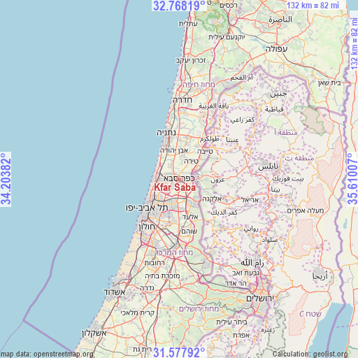
Kfar Saba GPS coordinates[2]
32° 10' 30" North, 34° 54' 24.984" East
| Map corner | latitude | longitude |
|---|---|---|
| Upper-left | 32.76819°, | 34.20382° |
| Center: | 32.175°, | 34.90694° |
| Lower-right: | 31.57792°, | 35.61007° |
| Map W x H: | 132.3×132.3 km | = 82.2×82.2mi |
| max Lat: | 33.27918° ⇑52.7% North |
| Kfar Saba: | 32.175° |
| min Lat: | ⇓47.3% South 29.55805° |
| min Long | Kfar Saba | max Long |
| 34.57149° | 34.90694° | 35.81084° |
| W 29.6%⇐ | ⇒70.4% E |
Elevation
Elevation of Kfar Saba is 57 m = 187 ft, and this is 166.4 m = 546 ft below average elevation for this country.
| Max E: |
988 m = 3241 ft | 67.5% |
| Avg. | 223.4 m = 733 ft | |
| Kfar Saba | 57 m = 187 ft | |
Min E: |
-380 m = -1247 ft | 32.5% |
See also: Kfar Saba elevation on elevation.city.
Geographical zone
Kfar Saba is located in North temperate zone (between Tropic of Cancer and the Arctic Circle). Distance of this Northern Tropic circle is 971.6 km =603.7 mi to South.| Distance of | km | miles | from Kfar Saba |
|---|---|---|---|
| North Pole | 6429.5 | 3995.1 | to North |
| Arctic Circle | 3823.6 | 2375.9 | to North |
| Tropic Cancer | 971.6 | 603.7 | to South |
| Equator | 3577.5 | 2223 | to South |


Nearby cities:
15 places around Kfar Saba: (largest is in red/bold)
• Even Yehuda
10.7 km =6.6 mi,  350°
350°
• Giv'at Shmuel
12.1 km =7.5 mi,  207°
207°
• Herzliya
7.7 km =4.8 mi,  262°
262°
• Herzliya Pituah
9.8 km =6.1 mi,  269°
269°
• Hod HaSharon
2.2 km =1.4 mi,  216°
216°
• Jaljūlya
4.9 km =3 mi,  117°
117°
• Kafr Qāsim
9.4 km =5.8 mi,  136°
136°
• Kefar Shemaryahu
8.2 km =5.1 mi,  278°
278°
• Nirit
8.1 km =5 mi,  112°
112°
• Petaẖ Tiqwa
9.9 km =6.2 mi,  190°
190°
• Ra'anana
3.3 km =2.1 mi,  287°
287°
• Ramat HaSharon
7.1 km =4.4 mi,  243°
243°
• Rosh Ha‘Ayin
10 km =6.2 mi,  152°
152°
• Tel Mond
8.4 km =5.2 mi,  6°
6°
• Tirah
7.7 km =4.8 mi,  31°
31°
Sources, notices
• [Note1] Compared only with cities in Israel existing in our database
• [Src1] Map data: © OpenStreetMap contributors (CC-BY-SA)
• [Src2] Other city data from geonames.org with taken over terms of usage.
• [Src3] Geographical zone / Annual Mean Temperature by Robert A. Rohde @ Wikipedia
