Tamra geodata
Tamra (Northern District) is a populated place; located in Israel in Asia/Jerusalem (GMT+3) time zone. With population of 25,917 people, there are 50 cities with bigger population in this country. Compared to other cities in Israel, 81.7% of cities are located further ↓South; 68% of cities are located further ←West and 53.3% of cities have higher elevation than Tamra. Note1


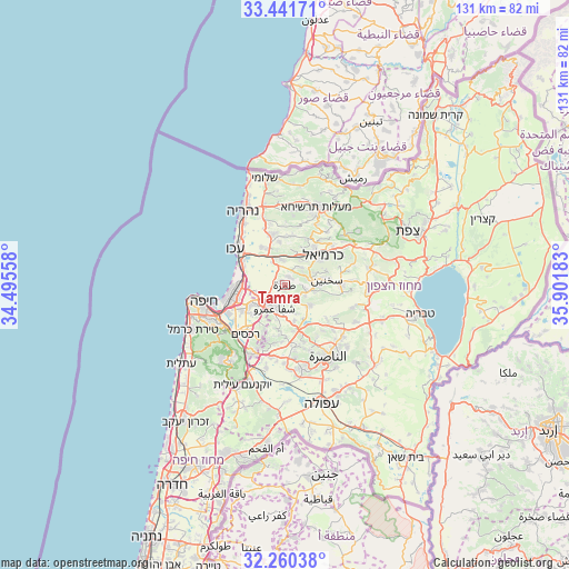
Tamra GPS coordinates[2]
32° 51' 10.836" North, 35° 11' 55.32" East
| Map corner | latitude | longitude |
|---|---|---|
| Upper-left | 33.44171°, | 34.49558° |
| Center: | 32.85301°, | 35.1987° |
| Lower-right: | 32.26038°, | 35.90183° |
| Map W x H: | 131.4×131.4 km | = 81.6×81.6mi |
| max Lat: | 33.27918° ⇑18.3% North |
| Tamra: | 32.85301° |
| min Lat: | ⇓81.7% South 29.55805° |
| min Long | Tamra | max Long |
| 34.57149° | 35.1987° | 35.81084° |
| W 68%⇐ | ⇒32% E |
Elevation
Elevation of Tamra is 92 m = 302 ft, and this is 131.4 m = 431 ft below average elevation for this country.
| Max E: |
988 m = 3241 ft | 53.3% |
| Avg. | 223.4 m = 733 ft | |
| Tamra | 92 m = 302 ft | |
Min E: |
-380 m = -1247 ft | 46.7% |
See also: Israel elevation on elevation.city.
Geographical zone
Tamra is located in North temperate zone (between Tropic of Cancer and the Arctic Circle). Distance of this Northern Tropic circle is 1047 km =650.6 mi to South.| Distance of | km | miles | from Tamra |
|---|---|---|---|
| North Pole | 6354.1 | 3948.3 | to North |
| Arctic Circle | 3748.3 | 2329.1 | to North |
| Tropic Cancer | 1047 | 650.6 | to South |
| Equator | 3652.9 | 2269.8 | to South |


Nearby cities:
15 places around Tamra: (largest is in red/bold)
• Basmat Ṭab‘ūn
13.3 km =8.3 mi,  197°
197°
• Bīr el Maksūr
8.7 km =5.4 mi,  166°
166°
• Ibṭīn
12.9 km =8 mi,  217°
217°
• Judeida Makr
9.2 km =5.7 mi,  335°
335°
• Kafr Mandā
7.4 km =4.6 mi,  129°
129°
• Karmi’el
12.2 km =7.6 mi,  54°
54°
• Kaukab Abū el Hījā
5.2 km =3.2 mi,  117°
117°
• Kfar Yasif
11.8 km =7.3 mi, 343°
• Kābūl
2.1 km =1.3 mi,  35°
35°
• Qiryat Ata
9.2 km =5.7 mi,  239°
239°
• Qiryat Bialik
10.9 km =6.8 mi,  254°
254°
• Qiryat Moẕqin
11.5 km =7.1 mi,  261°
261°
• Qiryat Yam
12.1 km =7.5 mi,  268°
268°
• Rumat Heib
13 km =8.1 mi, 129°
• Sakhnīn
9.3 km =5.8 mi,  82°
82°
Sources, notices
• [Note1] Compared only with cities in Israel existing in our database
• [Src1] Map data: © OpenStreetMap contributors (CC-BY-SA)
• [Src2] Other city data from geonames.org with taken over terms of usage.
• [Src3] Geographical zone / Annual Mean Temperature by Robert A. Rohde @ Wikipedia
