Qiryat Ata geodata
Qiryat Ata (Haifa) is a populated place; located in Israel in Asia/Jerusalem (GMT+3) time zone. With population of 48,966 people, there are 27 cities with bigger population in this country. Compared to other cities in Israel, 77.5% of cities are located further ↓South; 56.2% of cities are located further ←West and 75.7% of cities have higher elevation than Qiryat Ata. Note1


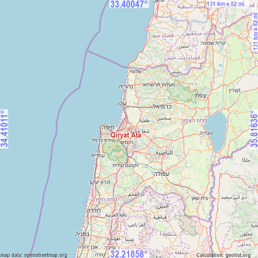
Qiryat Ata GPS coordinates[2]
32° 48' 41.364" North, 35° 6' 47.628" East
| Map corner | latitude | longitude |
|---|---|---|
| Upper-left | 33.40047°, | 34.41011° |
| Center: | 32.81149°, | 35.11323° |
| Lower-right: | 32.21858°, | 35.81636° |
| Map W x H: | 131.4×131.4 km | = 81.6×81.6mi |
| max Lat: | 33.27918° ⇑22.5% North |
| Qiryat Ata: | 32.81149° |
| min Lat: | ⇓77.5% South 29.55805° |
| min Long | Qiryat Ata | max Long |
| 34.57149° | 35.11323° | 35.81084° |
| W 56.2%⇐ | ⇒43.8% E |
Elevation
Elevation of Qiryat Ata is 46 m = 151 ft, and this is 177.4 m = 582 ft below average elevation for this country.
| Max E: |
988 m = 3241 ft | 75.7% |
| Avg. | 223.4 m = 733 ft | |
| Qiryat Ata | 46 m = 151 ft | |
Min E: |
-380 m = -1247 ft | 24.3% |
See also: Qiryat Ata elevation on elevation.city.
Geographical zone
Qiryat Ata is located in North temperate zone (between Tropic of Cancer and the Arctic Circle). Distance of this Northern Tropic circle is 1042.4 km =647.7 mi to South.| Distance of | km | miles | from Qiryat Ata |
|---|---|---|---|
| North Pole | 6358.8 | 3951.2 | to North |
| Arctic Circle | 3752.9 | 2331.9 | to North |
| Tropic Cancer | 1042.4 | 647.7 | to South |
| Equator | 3648.3 | 2266.9 | to South |


Nearby cities:
15 places around Qiryat Ata: (largest is in red/bold)
• Acre
13.4 km =8.3 mi,  345°
345°
• Basmat Ṭab‘ūn
9 km =5.6 mi,  153°
153°
• Bīr el Maksūr
10.7 km =6.6 mi,  110°
110°
• Haifa
11.7 km =7.3 mi,  273°
273°
• Ibṭīn
5.6 km =3.5 mi,  179°
179°
• Judeida Makr
13.6 km =8.5 mi,  17°
17°
• Kaukab Abū el Hījā
12.8 km =8 mi,  79°
79°
• Kābūl
11.2 km =7 mi,  55°
55°
• Nesher
8.2 km =5.1 mi,  232°
232°
• Qiryat Bialik
3.1 km =1.9 mi,  304°
304°
• Qiryat Moẕqin
4.4 km =2.7 mi,  310°
310°
• Qiryat Yam
5.9 km =3.7 mi,  316°
316°
• Ramat Yishay
13.1 km =8.1 mi,  155°
155°
• Rekhasim
7.1 km =4.4 mi,  190°
190°
• Tamra
9.2 km =5.7 mi, 59°
Sources, notices
• [Note1] Compared only with cities in Israel existing in our database
• [Src1] Map data: © OpenStreetMap contributors (CC-BY-SA)
• [Src2] Other city data from geonames.org with taken over terms of usage.
• [Src3] Geographical zone / Annual Mean Temperature by Robert A. Rohde @ Wikipedia
