Rekhasim geodata
Rekhasim (Haifa) is a populated place; located in Israel in Asia/Jerusalem (GMT+3) time zone. With population of 10,682 people, there are 83 cities with bigger population in this country. Compared to other cities in Israel, 71% of cities are located further ↓South; 53.8% of cities are located further ←West and 78.7% of cities have higher elevation than Rekhasim. Note1


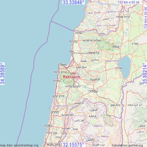
Rekhasim GPS coordinates[2]
32° 44' 56.652" North, 35° 5' 56.436" East
| Map corner | latitude | longitude |
|---|---|---|
| Upper-left | 33.33846°, | 34.39589° |
| Center: | 32.74907°, | 35.09901° |
| Lower-right: | 32.15575°, | 35.80214° |
| Map W x H: | 131.5×131.5 km | = 81.7×81.7mi |
| max Lat: | 33.27918° ⇑29% North |
| Rekhasim: | 32.74907° |
| min Lat: | ⇓71% South 29.55805° |
| min Long | Rekhasim | max Long |
| 34.57149° | 35.09901° | 35.81084° |
| W 53.8%⇐ | ⇒46.2% E |
Elevation
Elevation of Rekhasim is 43 m = 141 ft, and this is 180.4 m = 592 ft below average elevation for this country.
| Max E: |
988 m = 3241 ft | 78.7% |
| Avg. | 223.4 m = 733 ft | |
| Rekhasim | 43 m = 141 ft | |
Min E: |
-380 m = -1247 ft | 21.3% |
See also: Israel elevation on elevation.city.
Geographical zone
Rekhasim is located in North temperate zone (between Tropic of Cancer and the Arctic Circle). Distance of this Northern Tropic circle is 1035.4 km =643.4 mi to South.| Distance of | km | miles | from Rekhasim |
|---|---|---|---|
| North Pole | 6365.7 | 3955.5 | to North |
| Arctic Circle | 3759.8 | 2336.2 | to North |
| Tropic Cancer | 1035.4 | 643.4 | to South |
| Equator | 3641.4 | 2262.7 | to South |


Nearby cities:
15 places around Rekhasim: (largest is in red/bold)
• Basmat Ṭab‘ūn
5.6 km =3.5 mi,  101°
101°
• Bīr el Maksūr
11.8 km =7.3 mi,  74°
74°
• Daliyat al Karmel
7.8 km =4.8 mi,  218°
218°
• Haifa
12.9 km =8 mi,  306°
306°
• Ibṭīn
2 km =1.2 mi,  45°
45°
• Migdal Ha‘Emeq
15.5 km =9.6 mi,  121°
121°
• Nesher
5.5 km =3.4 mi,  290°
290°
• Qiryat Ata
7.1 km =4.4 mi,  10°
10°
• Qiryat Bialik
8.8 km =5.5 mi,  351°
351°
• Qiryat Moẕqin
10 km =6.2 mi, 348°
• Qiryat Yam
11.5 km =7.1 mi, 346°
• Ramat Yishay
8.3 km =5.2 mi,  126°
126°
• Tamra
14.8 km =9.2 mi,  38°
38°
• Timrat
12.7 km =7.9 mi,  113°
113°
• Tirat Karmel
12 km =7.5 mi,  275°
275°
Sources, notices
• [Note1] Compared only with cities in Israel existing in our database
• [Src1] Map data: © OpenStreetMap contributors (CC-BY-SA)
• [Src2] Other city data from geonames.org with taken over terms of usage.
• [Src3] Geographical zone / Annual Mean Temperature by Robert A. Rohde @ Wikipedia
